
New technology is pairing with local history, and at the same time, city staff are cooperating with Lincoln University.
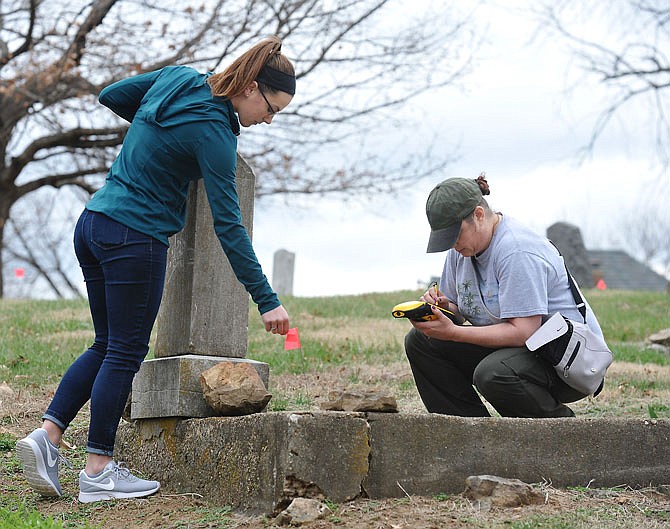
Students in the "Fundamentals of Global Positioning Systems (GPS)" class, taught by Samson Tesfaye, recorded data for about 75 headstones Monday in the Old City Cemetery's black section.
After spring break, the students will return to scan up to another 100 headstones.
That data will be shared with the city's GIS office, which will develop a map on the city website so the public can access the new information.
For the students, this is a chance to do the fieldwork after studying the programs in the classroom.
For the city, this is a chance to collect and share data staff otherwise likely wouldn't have the manpower or funds to do.
Three groups of students each had a mobile GPS receiver, which they used to take more than 20 points of recorded data about a marker's location. An average from that data provides the greatest accuracy, sophomore Sarah Gardner explained.
"In the classroom, we learned the mechanics of the process," she said. "We probably could do the fieldwork without the class, but we would not understand why."
The students also took a picture of each headstone and recorded the available personal information.
"It's not as easy as coming out here and using the GPS on your phone," sophomore Jeremy Morin said.
On the final website, the students' data will be combined with other historical and genealogical information collected by Nancy Thompson, chairman of the city's Cemetery Resources Board, and other local historians about specific individuals.
The city GIS office already maintains databases for other infrastructure, such as water and sewer lines.
"This will add another layer to our databases," GIS Manager Buster Schrage said.
Applying the technology to the cemetery can help reveal and preserve history, he said.
State officials, community leaders, veterans dating back to the Revolutionary War and other notable figures are buried at Old City/Woodland Cemetery.
The last mapping project was conducted by paper and pencil in 1976 by the local Daughters of the American Revolution chapter. At that time, they did not take photos, and since then, many of the markers they recorded have disappeared.
"The students are recording the actual location and making a permanent record," Thompson said.
She hopes this is not a one-time project but the beginning of an ongoing collection of data.
"I think the city has always wanted to do this," Thompson said. "By having the students here, the city has an impetus to participate, and it cuts their workload significantly."
In the past, Tesfaye's fieldwork assignments have been finding things on the campus quadrangle or local park. But this partnership allows the students to be part of a community service project.
"It makes us want to do the best job we can because it's not just for our education; it's for a purpose," Gardner said.
Lincoln's GIS program dates back to the early 1990s when it offered four courses in partnership with natural resources programs, Tesfaye said.
Since 2006, two additional courses attributed to the U.S. Department of Defense funding, which then created a minor in geospatial information science.
"We've grown leaps and bounds, and technology has significantly improved," Tesfaye said.
Those who choose this versatile minor mostly come from environmental science, agriculture and computer science degree programs.
The location technology has become commonplace, from tractors on farms to personal watches, Tesfaye said.
Earning this minor offers students extra skills that can open doors in the future, he said.
Through the GIS courses, students learn about remote sensing, photography, satellites, geographical information systems, cartography and surveying.
"They'll know how to collect data, how to process it and how to make a map," Tesfaye said. They also will know the proper standards for accurate and reliable data.
Both minoring in GIS, Gardner and Morin agreed the practical application validated their pursuit in the field.
"Satellites, hardware, software - it's vast and awesome," Gardner said.