
A fog settled in overnight and cool air surrounded Jefferson City early Monday morning.
It was perfect weather for a bike ride, Michelle Cline said.
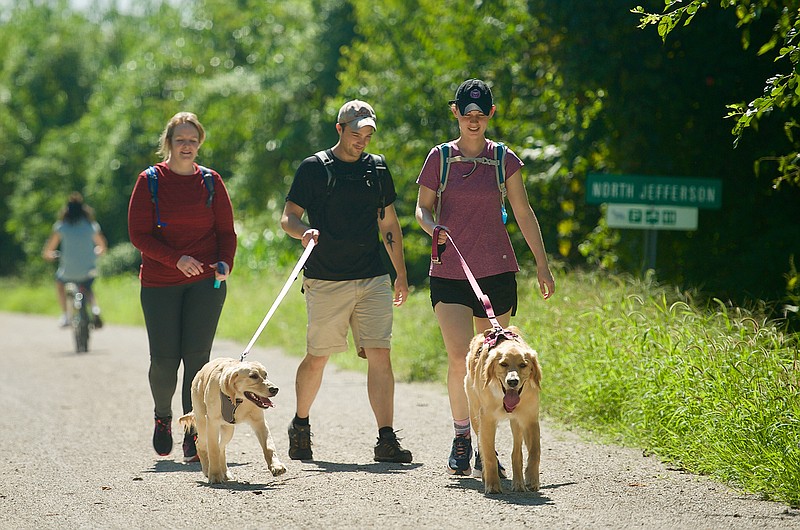
So she set out on an excursion along the Katy Trail with Shelly and Phil Wehmeyer.
"It was beautiful," Cline said when they returned to the North Jefferson trailhead. "The trail's in a lot better shape than it's been."
The condition along any stretch of the 287-mile trail can change daily, said Melanie Smith, Katy Trail coordinator for Missouri State Parks.
"Right now, the trail in the Jefferson City area is open in both directions. We still have a lot of areas that have rough surfacing," Smith said. "There is mud, if it's been rainy. That may not be fun to pedal through."
And places remain where the trail is washed out, or where the surface gravel has washed away. About 100 miles of trail were affected by flooding, she said.
Missouri State Parks maintains a number of web pages dedicated to the trail. At mostateparks.com/park/katy-trail-state-park there is data available to keep trail users up to date.
While on the Katy Trail main page, click on "advisories," which is found within "The Park File" drop-down.
From there, it's easy to check on current trail closures and alerts, sorted by where they fall on the trail map. For example, North Jefferson is at the 143.2 mile mark of the trail. The closest advisory on the list shows between mile marks 153 and 162.9 (west of Hartsburg to just east of Cooper's Landing) there is a closure because of the flooding (with no recommended detour), according to the report.
The website also has links to places where there are detours in place, and offers maps for the detours. A 1.4-mile detour (going west on the trail) from just south of Franklin to the Interstate 70 Booneville Bridge uses a stretch of Howard County Road 345 to Missouri 40.
People planning trips can also call Missouri State Parks to learn about trail conditions or other resources available.
For general questions, call 800-334-6946 or visit [email protected]
After the floods receded, crews hustled to clear the trail, Smith said.
"We've worked hard to remove the trees and the thick debris so people can enjoy the trail," she said. "The next step is to take dump trucks down through there, remove trees, smooth the trail and replace the surface."
The trail surface is traditionally crushed rock.
So, the trail is a mixed bag right now, she said.
"You'll find it's very spotty," she continued.
There are sections of the trail that appear the way they were before the floods, and there is debris all along the Missouri River.
"The big thing we want to encourage folks to do is visit that advisory page before they head out to the trail," Smith said. "That way, they'll know where there is work going on, or if there is work going on."
Major repairs are already taking place, she said. Crews are working in Montgomery County. Missouri State Parks crews have done some work near the North Jefferson parking area.
"We never know how many days they'll spend on any given spot," Smith said. "We are working with FEMA, and hopefully, there will be public assistance declared."
Missouri State Parks doesn't yet have a "ballpark figure" for how much flooding damage will cost to repair she said.
As of Thursday, the agency still had about 30 miles closed.
The Katy Trail was a popular destination Monday morning, Cline said.
"It's very busy out there today," she said.
Greg Schrock, of Holts Summit, took his grandson, 4-year-old Brody Case, out on the trail early in the morning. Schrock walked alongside Brody as he pedaled a small bike along the gravel.
"We probably went about 4 miles," Schrock said as they returned to the North Jefferson parking lot. "Brody got a little education about what the trail was."
Schrock said he explained the trail bed is actually part of a railroad bed.
The trail runs primarily along the right-of-way of the former Missouri-Kansas-Texas-Railroad.
The sun came out before noon, as a number of trail users finished their morning excursions.
Myra Rackers, and daughter Erica Rackers, both of Bonnots Mill, said they went out on Labor Day so they could have one last ride before Erica returned to Missouri State to work on her post-baccalaureate degree.
"It was great, but the trail was a little bit rough," Myra said. "We were supposed to go on the Katy Trail Ride this summer, but they canceled it."
The ride, which was scheduled for June 17-21, raises money for Missouri State Parks Foundation. It lets people enjoy the nation's longest developed rail trail, according to the Missouri State Parks website.
However, widespread flooding caused more than 100 miles of trail to be closed during that week.