
An unlabeled, nearly 200-year-old map, safely stored in the Missouri State Archives, became the starting point to discovering the earliest roads in southeast Missouri, specifically ones the Cherokee may have followed on the Trail of Tears.
Earlier work on the Trail of Tears National Historic Trail plotted a course through the Bootheel, which was covered in extensive swamps and thick with cypress trees.

Finding that unlikely, Missouri Department of Transportation archaeologist Rusty Weisman began to look for accounts of the earliest roads, the ones likely used for centuries by the indigenous people long before the first Europeans arrived.
Using early travel accounts through personal journals and correspondence, Weisman was able to re-create the road's likely path by landscape descriptions and property owner names.
For example, the Stephen Long expedition, the first scientific exploration of the Louisiana Purchase, began in 1819 and returned through Arkansas, Greenville and Cape Girardeau.
But the road changed alignments between that expedition and the 1837 map he found in the state archive, he said.
Then, in the Cape Girardeau County Archive, Weisman found the state legislation to build the first state road in southeast Missouri.
With his pieced-together information, Weisman used a computer-aided mapping program that allowed him to overlay the old maps and locations onto a modern map.
Although some of the 19th century measurements came up short, Weisman was surprised at the overall accuracy, he said.
Now armed with a likely location, the archaeologist met up with a colleague to investigate in the Mark Twain National Forest.
"It was stunning; the historic road was still on the ground, and you could follow it," Weisman said.
They were neither paved nor flat, like modern roads. These roads had no drainage or bridges. Mostly, they followed the logical, natural paths to avoid water and other natural hazards.
"They were worn into the ground in such a way that they were rather long-lasting," Weisman said.
The remaining feature of these historic roads crossed slopes and sometimes had braided sections, which assured them these were not naturally occurring features.
Once the road was identified, the archaeologists had to relate it to historical events, like the Civil War, western migration and the Trail of Tears.
Migration after the War of 1812 increased into the west, and even more after the financial crisis of 1819 moved farmers west to start over.
"It's pretty cool you can go find the road they traveled on and even some of the houses they stayed in," Weisman said.
MoDOT's interest in this road and the Trail of Tears was as "creative mitigation" for another project's inadvertent impacts at existing Lake Wappappello, National Park Service and Corps of Engineers sites, Weisman explained.
For the last several years, Weisman has been part of a broad group of organizations helping to confirm and bring to life the Missouri portion of the Cherokee story.
Just in time for November - Native American History Month- educational markers were dedicated recently at the Old Greenville/Bettis Ford site at Wappapello Lake. This is near where the Cherokee's Benge Detachment crossed the St. Francis River in December 1838.
Organizations involved in the project's research, archaeology and development include Missouri Chapter of the Trail of Tears Association, St. Louis District U.S. Army Corps of Engineers, Wappapello Lake, Poplar Bluff District Mark Twain National Forest, the Trail of Tears Association, National Park Service, National Historic Trails and the Poplar Bluff Chapter of the Daughters of the American Revolution.
This marker is one piece of the larger effort to identify the entire 800-mile route from the Native American's tribal homeland in the east to Indian territory, today Oklahoma.
Historic trails are unusual, as roads are long and linear rather than in one spot.
"This was a good opportunity to collaborate," he said.
Weisman said he intends to remain involved, personally, and would like to see campsites and cemeteries related to the Trail of Tears in Missouri identified in the future.
"The Trail of Tears project is more impactful than other stuff we do," Weisman said. "It's more easily accessible than rocks and other things."
MoDOT chronicles the Trail of Tears
Courtesy of Rusty Weisman/Missouri Department of Transportation and the National Park Service:
During the first week of December in 1838, a group of more than 1,100 Cherokees passed through Old Greenville on their Trail of Tears journey to the Indian Territory, in what is now Oklahoma.
Led by John Benge, they were one of 13 groups of Cherokees displaced from their traditional homeland in the East by the Indian Removal Act of 1830. Traveling under their own supervision, nearly 13,000 Cherokees made the overland trek west during the fall and bitterly cold winter of 1838-1839, on what is now known as the Trail of Tears.
The Benge Detachment included a number of families from Wills Valley in northeastern Alabama, some of them wealthy slave owners. A few Muscogee Creeks living among the Cherokees also traveled west with the Benge Detachment. John Benge led his detachment on a unique route to the West.
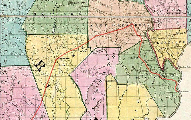
After traversing Tennessee, they crossed the Mississippi River at Columbus, Kentucky. Then, following well-established roads around the swamps of southeast Missouri, they circled north through the towns of Charleston, Benton, and Jackson.
When the Benge Detachment reached Old Greenville, with their 60 wagons and 600 horses, the diverse group had been on the road for nine weeks and faced another six weeks of winter travel over rough roads. They waded across the St. Francis River at Bettis Ford.
Averaging between 10 and 15 miles per day, they then crossed the Current River above Hix Ferry on December 8th, and were near Smithville, Arkansas, on December 12th, and at Batesville on the 15th.
The Benge Detachment forded the White River in Arkansas at Talbert's Ferry and then proceeded west through Fayetteville. After reaching Indian Territory, they disbanded near Stilwell, Oklahoma, on Jan. 11, 1839. Three births and 33 deaths were recorded during the Benge Detachment's grueling 103 day, 770-mile Trail of Tears journey to the West.
The Trail of Tears National Historic Trail helps to preserve the history of the forced removal of the Cherokee Nation, as well as other southeastern Indian tribes, including the Choctaw, Muscogee Creek, Seminole, and Chickasaw, who were dispossessed by the Indian Removal Act of 1830. The Bettis Ford and Old Greenville sites are part of the Trail of Tears National Historic Trail commemorating those events.