
Travelers depended on roadside parks in the early years of paved highways.
The first roadside park in Missouri reportedly was opened in Taney County in 1929.
At the peak of their popularity in the 1960s, more than 120 roadside parks or rest areas were opened along Missouri highways.
These parks served a threefold purpose: contributing to safety, preserving natural scenic beauty, and offering convenience for those who wished to eat along the roadside, said Toni Prawl, senior historic preservation specialist with the Missouri Department of Transportation.
West of Jefferson City, the Ten Mile Drive Roadside Park was a popular place for picnics and family outings. In the 1960s, that roadside park was impacted by U.S. 50 construction and relocated to its present location in the 2500 block of Missouri Boulevard.
"Many roadside parks have been abandoned through the years for a variety of reasons," Prawl said.
Interstate development, more modern rest area facilities, lack of use, liability and maintenance issues and changing public interests were some.
When the MoDOT historic staff researched roadside parks in 2005, they found about 80 roadside parks and rest areas remaining.
The 1930s rustic architecture style was adopted by Missouri as a result of the National Park Service promoting it within the New Deal programs, such as the Civilian Conservation Corps and the Works Progress Administration.
In its 1938 report, the Missouri State Planning Board stressed the importance of highways and urged the Missouri State Highway Commission to conduct roadside improvements to promote motoring as a form of recreation, Prawl said.
Construction was suspended during World War II. Then a building boom followed in the 1950s, when the number of roadside parks nearly doubled, she said.
"Almost always the result of grassroots efforts and the highway department's response to local requests and interests, parks usually had sponsors or benefactors behind them," Prawl said.
MoDOT preferred sites at least two miles outside city limits and, once approved, the land generally was donated.
Local park sponsors often furnished plantings and other aesthetic materials, like picnic tables or fireplaces.
The 1957 Missouri highway map promoted the roadside parks as a place to "get away from the hurry of the highway for a brief period" by stopping to rest, eat lunch and enjoy the natural scenery.
The official 2013 Missouri State Highway Map was released this month, highlighting state parks, conservation areas, historic sites, hospitals, airports, Amtrak stations and more.
As travelers' needs have changed, so has MoDOT's attention, as the map shows.
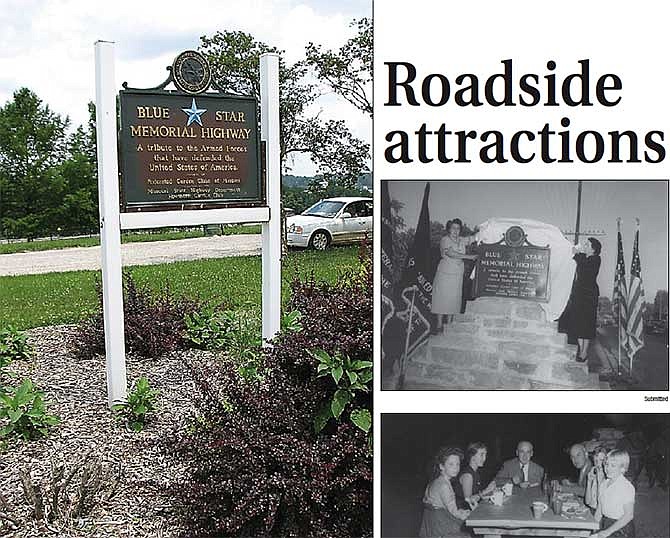
The roadside parks also became a preferred site for memorials, too.
The National Garden Clubs of America implemented the Blue Star Memorial Highway in 1944, to create a living tribute to the men and women of the nation who served in the armed forces of World War II.
The highway commission approved double rest areas along the new interstates in 1965, increasing from nine to 17, which were strategically located at approximate one-hour driving intervals and away from larger urban area.
Travelers favored the new stops, because they had up-to-date facilities, including restrooms and water.
The roadside parks offered a high visibility for the honor, but today some have been relocated to interstate rest areas.
The State Historical Society of Missouri also sponsored historical markers to depict events and histories specific to the county in which they were erected.
And sometimes, local parks were memorials themselves, in remembrance of loved ones of the land donors.
The Jefferson City park, no longer an official MoDOT roadside park, features both the historical society and Blue Star markers, as well as a Spanish-American War statue.
The society and state highway commission erected the Cole County marker in 1953.
One side addressed the Capitol location in the Ozark foothills on land ceded by the Osage Indians, and it lists several points of interest downtown.
The other side discusses the city and county, including namesake Stephen Cole, a pioneer, and notable dates such as the Missouri State Penitentiary opening in 1833, the Missouri Pacific Railroad arriving in 1855, Lincoln University opening in 1866 and the opening of the first Missouri River bridge in 1896.
The Spanish-American War monument was created by the now-defunct United Spanish War Veterans Department of Missouri, which commissioned St. Louis sculptor Carl Mose.
The bronze figure was erected in 1963 at a different location, but found a home at the Missouri Boulevard site by 1967.
Memorial's inscription reads: "Dedicated To The Honor and Memory Of More Than 10,000 Missouri Volunteers Who Served In The War With Spain 1898 - 1902 Cuba, Manila, Puerto Rico, Boxer Rebellion, Phillipines."