
Mid-Missouri has dodged a bullet - for now.
After several days of heavy rain, the Missouri River in Jefferson City crested lower than predicted, according to the National Weather Service Office in St. Louis.
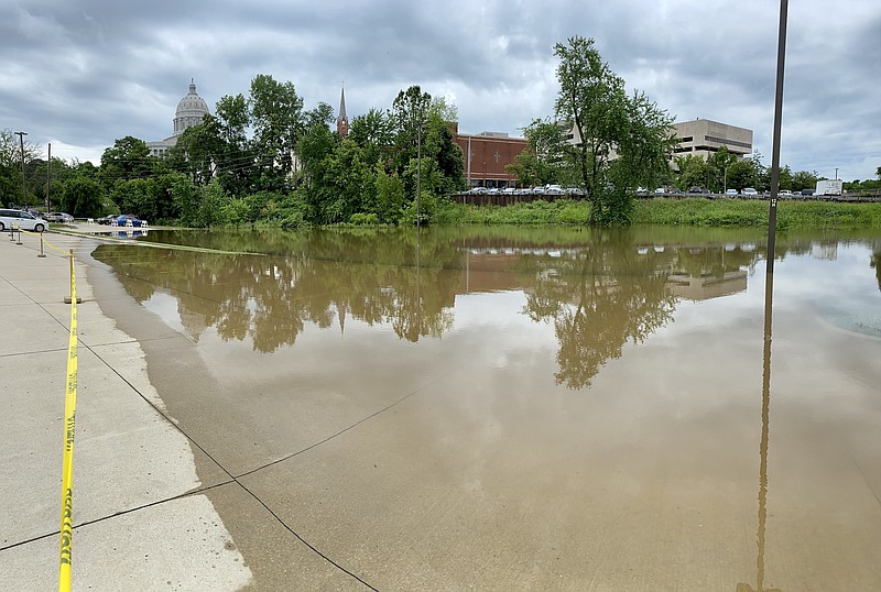
As of Monday afternoon, the river crested at 27.4 feet and was down to 26.9 feet by 2 p.m.
The forecast heading into this past weekend had predicted the river could rise to near 30 feet. Flood stage is 23 feet.
NWS Meteorologist Ben Herzog said more rain is predicted throughout much of this week, but likely not producing the rapid jump in river levels that last Thursday and Friday's torrential rains did.
"Trying to predict summer river levels is very hard since we only incorporate the next 24-hour precipitation forecast into the prediction for the river level," Herzog said. "Anything beyond that is not incorporated in the river forecast."
Moderate flood levels should remain in Jefferson City for a few more days.
"If the rain is heavier, that of course could change, but the tremendous amounts we saw last week are extremely rare," Herzog said. "It's not impossible, but an event like that is more than likely not to happen again."
Roger Fischer, chair of the Heartland Port Authority and Callaway County Western District commissioner, hopes this latest flooding event brings more attention to the continued potential for severe flood damage.
"According to NWS figures, the river has crested 10 times above 26 feet since 2015 in Jefferson City, and since 1973 there have been six times it's gone over 31 feet," Fischer said. "We need more levees to protect the north riverbottoms. That could help expand Jefferson City. I think that could eventually help develop that area into something like what you see in Chesterfield off of I-64."
The U.S. Army Corps of Engineers is working on the Lower Missouri Basin Flood Risk and Resiliency Study to help identify flood-risk areas along the river in Nebraska, Kansas, Iowa and Missouri. Likely to take years to complete, it will look at structural and non-structural options for flood risk, including possibly modifying existing levees and/or the river channel.
Cole County Engineer Eric Landwehr said the county's public works department had about 20 calls about flooding and roadway issues from the weekend storms.
"We have a lot of gravel roads that have washed out and pipes that are clogged with debris," Landwehr said Monday. "Our staff is going out to make repairs and check on the complaints."
Britt Smith, Jefferson City Department of Public Works Operations Division director, said city staff is still identifying damage from flooding.
So far there appears to be more damage on the western side of the city, but it could be that other areas have not been identified yet, he said.
"There's so many of them," Smith said Monday. "The flooding was pretty extensive. We're obviously looking to see what we can find everywhere. Right now, we've been more in clean-up mode and making sure roads are open. Then we'll start addressing the damage. It hasn't been quite long enough for me to be confident that I've identified all the areas that have issues yet."
Anyone aware of flood damage can call the Jefferson City Public Works Department at 573-634-6410 or file a report on the city's website at jeffersoncitymo.gov/government/contact_public_works.php.
Weekend flooding also affected the Washington Park Ice Arena, which is closed until further notice.
Assistant Parks Director JJ Gates said cleanup is moving along at the ice arena. When that amount of water gets onto the ice, it's best to let the whole thing melt and re-lay the ice, he said.
"It pretty much melts it pretty quick, and there's no way of saving it," Gates said. "So we turn the equipment off and we just let it melt, and then we clean up and we have to remake it."
The process can take several weeks to a month.
Gates said flooding is always a concern, but projections for the Missouri River are keeping its crest below the Capital View Levee, which is built to protect to a height of 30 feet. That means there's a lower risk of Washington Park flooding.
"We'll be a little gun-shy until we get through this forecast that's happening through Thursday now," he said.
Binder Park also saw flooding over the weekend and some culverts washed out. There will be necessary repairs to other parks facilities, but manageable ones, he said.
"It's going to take some effort to get those (culverts) back into shape without losing pavement and whatnot," he said.
All parks facilities besides the ice arena are open.
City Engineer David Bange said the storms likely delayed some work on the Bicentennial Bridge - which was started in February and will stretch from the Missouri State Capitol to Adrian's Island.
While Adrian's Island didn't flood, he said, the contractor moved equipment off the area out of an abundance of caution.
"Certainly the river getting up did make us nervous," he said.
It becomes a question of whether Adrian's Island is dry enough to move equipment back onto it.
Since it's mostly sand, it should dry out fairly quickly, Bange said, but there's a pillar cap that needs poured before the next set of girders can go in place. That has likely been pushed back to at least Wednesday, and more rain could push that back further.
At this point the city is mostly concerned about whether there will be another flash flood, since that can overwhelm the system and make draining an issue, Smith said.
"If you get a half-inch of rain over a two-hour period, that's going to be no problem," he said. "It's when we get those 1-inch rains in 15 minutes, water is going to back up suddenly into places where people weren't expecting."
More information:
Weather forecast, radar, warnings and advisories at https://www.weather.gov/lsx/
Eastern Missouri river stages at https://water.weather.gov/ahps2/index.php?wfo=LSX
Western Missouri river stages at https://water.weather.gov/ahps2/index.php?wfo=eax
Missouri Traveler Information Map at https://traveler.modot.org/map/index.html
Ameren's Truman and Bagnall Dam daily report at https://apps.ameren.com/HydroElectric/Reports/Osage/HSTBagnellDaily.aspx
National Weather Service updates for Missouri on Twitter at https://twitter.com/i/lists/1131249702131781632