
Photo Gallery
Conway ArtsFest

Conway celebrated arts at various shops, galleries and outside venues. Friday night's cold weather moved the jam session inside but didn't dampen the spirit of the musical crowd. Some people brought their own instruments, others jumped in for impromptu music making with Marco Granados and Un Mundo.
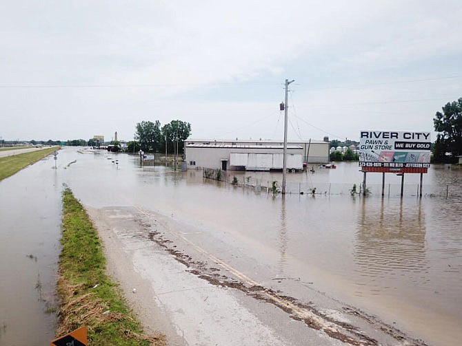
As of Tuesday afternoon, the Missouri River in Jefferson City was at 31.7 feet, and the National Weather Service in St. Louis was forecasting it would reach 32 feet by late today or sometime Thursday. The forecast called for the river to stay around 32 feet until early next week. It would not get below the flood stage of 23 feet until next weekend.
Due to heavy rains in the upper reaches of the Missouri River, the U.S. Army Corps of Engineers announced Tuesday they'll be increasing releases into the Missouri from their southern most dam.
Corps officials said releases from the Gavins Point Dam in South Dakota, would increase by 5,000 cubic feet per second Tuesday and an additional 5,000 cfs today.
Over the last seven days, rainfall over much of Nebraska, South Dakota and central North Dakota has been 200-600 percent of normal amount for this time of year. The continued rain has led to higher inflows at Oahe, Big Bend, Fort Randall Dams, which are farther up from Gavins Point.
"The inflows into Oahe are still high and with pool levels in their exclusive zones at the Oahe and Fort Randall reservoirs, we need to ensure we have space available to manage additional runoff," said John Remus, chief of the Missouri River Basin Water Management Division.
Remus added increasing the releases from Gavins Point Dam will allow more water to pass through the system and slow the rise in the pool levels at these projects.
Corps officials said the effects from releases on the lower Missouri River diminishes at locations further downstream due to the large uncontrolled drainage area and the travel time from Gavins Point Dam. Travel times for releases from Gavins Point take two to three days to reach Omaha, three to four days to reach Nebraska City, and four to five days to reach Kansas City.
Releases on the Missouri will remain higher than average into the fall because the reservoirs have to be at the base of the annual flood control pool by the beginning of the 2020 runoff season.
Meanwhile, the Corps Harry S. Truman Lake at Warsaw is 82 percent full, leaving minimal space to store additional floodwaters.
Due to ongoing precipitation in the region, Corps officials began releasing water through the dam powerhouse this week. Releases are coordinated with the National Weather Service and Ameren, the operators of Bagnell Dam. Corps officials said this May has been the second highest monthly inflow to Truman in the dam's history.
All Corps dams are reported to be structurally sound and preforming as designed.
Ameren officials said Tuesday they were monitoring the Lake of the Ozarks levels, but had not made a decision as to if or when they would be increasing releases at their facility.
As of Tuesday afternoon, MoDOT had not changed any of it's local road closures due to flooding. Hibernia Road, Airport Road, Cedar City Drive, Route W and Missouri 94 were closed due to flooding in and around North Jefferson City.
In Jefferson City itself, Missouri Boulevard along Wears Creek, which backs up with flood waters from the Missouri, was closed in the Millbottom area, affecting state parking lots. MoDOT officials said unless the weather conditions change, U.S. 54/63 should remain open. Information from the weather service indicated U.S. 63 north of the city would begin to flood if the river reached 34 feet, and U.S. 54 north of the split with U.S. 63 would start flooding if the river reached 37 feet.
In Callaway County, the following roads were inaccessible due to flooding: Missouri 94, east of the U.S. 54/63 interchange; Missouri 94 at Logan Creek, west of Portland; Missouri 94, between Route PP and Steedman; and Route C in Mokane.
Mokane residents may be inconvenienced due to the floodwater but seem to be largely handling it well, Callaway County Sheriff Clay Chism said.
"Over the past several days, we've conducted frequent patrols of the area and had several casual contacts with local residents," he said Tuesday. "As many residents of the Mokane area have experienced major floods before, they are most familiar with dealing with the flooding situation."
The sheriff's office did respond to one report of a stranded motorist Friday on Route C.
"Upon the arrival of emergency responders, the vehicle had already been removed and it was verified the vehicle occupants were fine," Chism said.
Weather resources:
Ameren's Truman and Bagnall Dam daily report
Missouri state highway road closings