
"Those who don't learn history are doomed to repeat it."
The quote from philosopher George Santayana could easily apply to recent flooding along the Missouri River basin. The primary driver for flooding in 1993 was a prolonged period of heavy rainfall, quickly overwhelming the Missouri River levee systems.
History seemed to repeat itself this year.
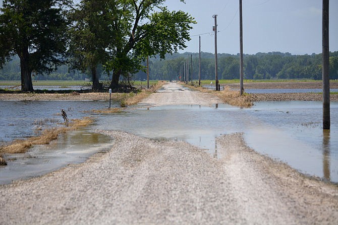
Since March, Mid-Missouri has seen several periods of heavy rain, and on April 1, the first of four crests this year on the Missouri in Jefferson City occurred when the river reached just over 28 feet.
On May 3, the river once again crested at just over 28 feet. By May 7, the U.S. Army Corps Engineers announced it expected water releases from all its dams on the upper end of the Missouri to be above average for the next several months, possibly lasting as late as November.
Corps officials said this was due to record runoff from snowpack in the north, which in some areas, was the highest seen since record-keeping began in 1898. That runoff goes into the river, which - combined with record rainfall along many parts of the Missouri - led to damaging flood conditions downstream.
Since May 7, the river has crested at 26.5 feet May 12 and at 33.4 feet June 5, which is the fourth highest crest ever recorded in Jefferson City. This weekend, the river is expected to crest just below 31 feet.
This year's flooding was immediately compared to the historic flooding of 1993, which saw the river crest at 38.6 feet on July 30 of that year.
Shortly after the Flood of 1993, Jefferson City went to work on a buyout program for what was then Cedar City. More than $1.7 million was paid in flood buyouts for 162 residential properties, primarily in the old Cedar City area. The properties bought were demolished, moving people out of the floodplain, and deed restrictions stated the land could be used only for open space and agricultural uses. Only a few homes remain in what was the former town.
Two notable structures still sit north of the river - Jefferson City's wastewater treatment plant and the Jefferson City Memorial Airport.
The water treatment plant was rebuilt and elevated by several feet to take it out of the 100-year floodplain. The airport would have to be raised 9 feet to take it out of the floodplain, and city officials deemed that cost-prohibitive.
There was also discussion after the '93 flood about building a new levee along the northern front of the river. This "super levee" would have been 43.9 feet tall had it been built. That's 13.9 feet taller than the agricultural levee that sits on the northern front of the river and 5.3 taller than the crest of the '93 flood.
The levee was projected to cost $21.39 million, with a quarter of those funds coming from a local sponsor, but after federal funding came in less than expected, the project fizzled out.
Since 1993, the goal of the U.S. Corps of Engineers has been to continue to check conditions of levees but also determine the drivers for risks that could cause failures, said Jud Kneuvean, chief of emergency management for the Corps Kansas City District.
"It's a shared responsibility," he said. "There's no one agency that has authority or a solution to solve flooding problems. If you live and work behind the levee system, then it's our role to educate you and to have responsibility to help you realize that you have responsibility to keep out of harm's way.
"That's not as easy as you'd think because you have to figure out: How do you take a technical topic and convey to a lay person? We're not trying to abdicate responsibilities but acknowledge we don't have all the answers and work very hard to provide the best information to the public."
Flood season typically starts in late March to early April, while major flooding tends to occur from the end of May through the middle of July. But even in a dry year, flooding can occur at any time, Kneuvean said - just one rainfall event can cause rivers to rise quickly.
"Mitigation measures such as elevating of flood-prone areas and relocating homes and businesses out of a floodplain, like what we saw with North Jefferson City/Cedar City after the 1993 flood, is the best way to reduce flood risks. But that's easier said than done," he said. "If you have too much time between major flood events, then people tend to forget the dangers. You will have some movement back into these areas, and they have to learn all over again."
Jefferson City Operations Division Director Britt Smith, who serves on the Capital View Levee district board, said Capital View was under water for three weeks before this week's flood surge on the river.
"There were multiple breaks on the east side of the levee, which is where the airport is located," Smith said. "I was not here in '93, but from what I've been able to study, the damage so far is no where close to '93 because of the homes that were here when Cedar City was in existence."
Although there is no longer a community in North Jefferson City, Smith said the damage suffered to businesses at the airport as well as other businesses such as MFA and the Turkey Creek Golf Center/Capital View Event Center is and will continue to be huge as long as the flooding lasts.
"The folks here in '93 have said it took a long time, as a much as a year or more, to make repairs," Smith said. "Hopefully we'll be able to have the west side stay dry, but the east side, where the airport sits, is really beat up. When the water did go down for a while, we found one area of the levee that could have a 1,000-foot gap, along with two smaller gaps. We can't get to those for a while, so I have no idea how long it would take to fix those gaps."
Jay Fischer, owner of Fischer Farms and who also serves on the Capital View board, talked with a representative of the Corps on Friday who had come down to look at the damage in the levee area.
"There are five total breaks that we know of," said Fischer, whose farm is on the east side of the levee. "What we really worry about is how deep holes could be under the base of the levees. The man from the Corps told me that in areas of northern Missouri, they were able to find holes as deep as 85 feet. They estimated that could cost as much as $2.5 million to fix."
The holes were created when water erodes dirt in the levee, creating a hole that can weaken the structure.
When the water went down last week, Fischer said, he was able to drive to his farm. But since the river has come back up, he's back to using his boat to get out to the area; it's something he does every day.
"It's unreal how much water we've been seeing," Fischer said. "We've been going through this for five weeks. It's not as long as what we dealt with in '93, and I hope it doesn't surpass that. I think the predictions in '93 were more accurate than this year.
"I'm not running anyone down, but it has been frustrating trying to figure out what you can do on a river forecast that seems, at times, to change multiple times in one day," Fischer said. "It's hard to plan to do things when the water goes down and comes back up again in a short time. I like to look at things with the glass half-full, but it's been frustrating this year."
Terry Hilgedeck, who serves on the Hartsburg Levee District Board, said about half of Hartsburg is protected by levees, and sandbagging efforts helped to shore up low spots and prevented even more damage from occurring this spring.
The Hartsburg district is made up of three sections of levees, all considered agricultural, that protect 3,500 acres of land in southern Boone County.
"I would compare the damage (from this year) to what we saw in the Flood of '95, not 1993," Hilgedeck said. "The water was probably 6-7 feet higher in '93."
Despite the sandbagging efforts, the farmland in the levee district was flooded, and Hilgedeck said the repair work will take a lot of time to complete.
"We are a long ways from getting to where we can get out and start doing repair work," he said. "We need a 15-foot river and some prolonged dry conditions. Given the volume of releases coming from Gavins Point Dam at the northern end of the river (in South Dakota), it may be a long time before we get to those conditions."
Last week, Corps officials said they would be releasing 70,000 cubic feet of water from Gavins Point for the foreseeable future.
Costs of repairs
Repairs to flood-damaged levees and other infrastructure will cost far in excess of $1 billion, the Corps of Engineers announced last week.
The Associated Press reported the Corps has received more than 150 project applications for federal funding so far along the Platte and Missouri rivers, but more are expected to roll in. More than 100 levees between Omaha and St. Louis have been breached, but only a handful repaired so far.
Locally, four of the five levees along the Missouri River in the Jefferson City area were overtopped and breached by recent flooding, according to damage assessments from the U.S. Army Corps of Engineers Office in Kansas City.
The levees that were damaged included:
Capital View - a levee classified as both agricultural and urban across the river from downtown Jefferson City on the left descending bank.
Part of the Capital View Levee broke Thursday on old Route W, near Cedar City Drive, leaving a foot-wide hole which expanded to 20-30 feet wide in about a half an hour. A combination of public and private entities hauled in rock and material to fill in the hole. Emergency repairs made to the levee were holding up this weekend, officials said, as the river began to slowly recede.
Renz - an agricultural levee upstream of Jefferson City on the left descending bank of the river.
Reveaux - an agricultural levee downstream of Jefferson City on the left descending bank.
Wainwright - an agricultural levee downstream of Jefferson City on the left descending bank.
The Cole Junction levee, an agricultural levee upstream of Jefferson City on the right descending bank of the river, did not overtop, but did sustain erosion damage.
Those four levees were part of nearly 850 river miles that were damaged when two rounds of massive floods devastated huge swaths of the Midwest this spring and early summer. Resulting problems included complete breaches in levees, deep scour holes, erosion to the armoring of the river banks and toppling of in-stream dikes that direct the water's flow, the AP reported.
Officials expect the repairs to take several years.
Who pays for repairs
Levees are designed to minimize the damage of floodwaters as they leave the normal channel of the river.
There are two types of levees - federal and non-federal.
Non-federal levees are privately built and are not inspected annually. They are not as high as federal levees and are usually on the edge of the river.
Federal levees are built to the 100-year flood level plus 3 feet. The 100-year flood level protects against a flood that has a 1 percent chance of happening in any given year.
The Corps has two classifications of levees - agriculture and urban. Agricultural levees protect primarily farm fields to approximately 15- to 20-year flood levels, while urban levees provide higher levels of protection to population centers and large commercial-industrial properties, such as Jefferson City Memorial Airport.
Many of the levee systems along the Missouri River have not had significant alterations since the early 1970s. Initial construction for many dates back to the early 1920s.
All of the levee systems in the Jefferson City area are non-federal levee systems. They were designed and/or constructed locally by levee or drainage districts or other public entities. These groups maintain their levee systems in accordance with certain criteria to be eligible for repair assistance when they are damaged by floods.
Because they are all non-federal levees, the cost to repair the Jefferson City area levees is shared between the federal government and the local levee sponsor.
The federal share is 80 percent, and the non-federal share is 20 percent of the actual construction costs. The non-federal share can be provided as work-in-kind or cash or a combination of both.
In addition to the 20 percent cost-share, the local sponsor is responsible for providing without cost to the federal government all lands, easements and rights-of-way necessary to complete the repairs.
The path for repairs
Kneuvean, with the Corps' Kansas City District, said it may take up to two years to repair all of the levee systems that were damaged this year. The Corps' goal, he said, is to have damage assessments of levees damaged in flooding between March and May completed by the end of September.
"We expect this effort to be the largest levee rehabilitation effort since 1993," Kneuvean said. "Damages up and down the system from Rulo, Nebraska, to Washington, Missouri, are significant."
So far, the Corps has awarded three contracts totalling $30 million to make levee repairs along the Missouri River in Iowa and one in northern Missouri.
There was a high number of damaged levee, Kneuvan said, but the levee systems performed "exceptionally" during the recent flooding.
"We have had no reports of levees breaching prior to being overtopped," Kneuvan said. "All performed as designed. Local levee sponsors get the credit for that. They also were on the front line of the flood fight and did everything they could to ensure that the levees performed under the recent river conditions."
Local levee districts are already considering the costs of repairs.
"Levee districts set their tax rates in August, and those go out on property tax bills of those property owners served," Hilgedeck said. "With (levee damage) assessments still going on, it's unknown what those rates will be, but it's definitely going to be a long road to recovery. Levee repairs are expensive, probably double the cost from '93."
Corps officials and officials with the National Weather Service said the likelihood of additional flooding this summer remains high.
"Past performance is never a guarantee of future performance," Kneuvean said. "All who work or live behind levee systems should remain vigilant and both weather and river aware."