
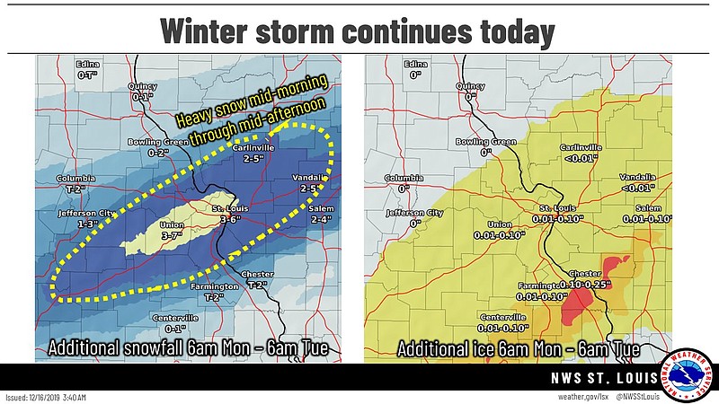
The Winter Storm Warning continues for much of Mid-Missouri until midnight tonight with the forecast calling for more snow, according to the National Weather Service.
Snow is likely today, possibly mixed with freezing rain before 7 a.m., then snow. The highs are forecast to be in the upper 20s with north winds at 7-10 mph. New snow accumulation of 2 to 6 inches is possible.
...WINTER STORM WARNING REMAINS IN EFFECT UNTIL MIDNIGHT CST TONIGHT...
* WHAT... Heavy mixed precipitation is expected. Additional snow accumulations of 2 to 6 inches and ice accumulations of a light glaze.
* WHERE... Portions of central and east central Missouri and south central and southwest Illinois.
* WHEN... Until midnight CST tonight.
* IMPACTS...Plan on slippery road conditions. The hazardous conditions could impact the morning or evening commute.
* ADDITIONAL DETAILS...Snowfall rates of 1 to 2 inches per hour are possible at times today. This will cause rapid accumulation on roads and treacherous driving conditions.
PRECAUTIONARY/PREPAREDNESS ACTIONS... A Winter Storm Warning means significant amounts of snow, sleet and/or ice are expected to occur. Strong winds are also possible. If travel is necessary, make sure to exercise extreme caution. Begin your travel with a full tank of gas, and carry a winter storm kit which includes a shovel, flashlight, cellphone, food and water, and blankets of extra warm clothing.
See also:
School closings and weather-related announcements for Monday, Dec. 16, 2019
MoDOT statewide traveler information map