
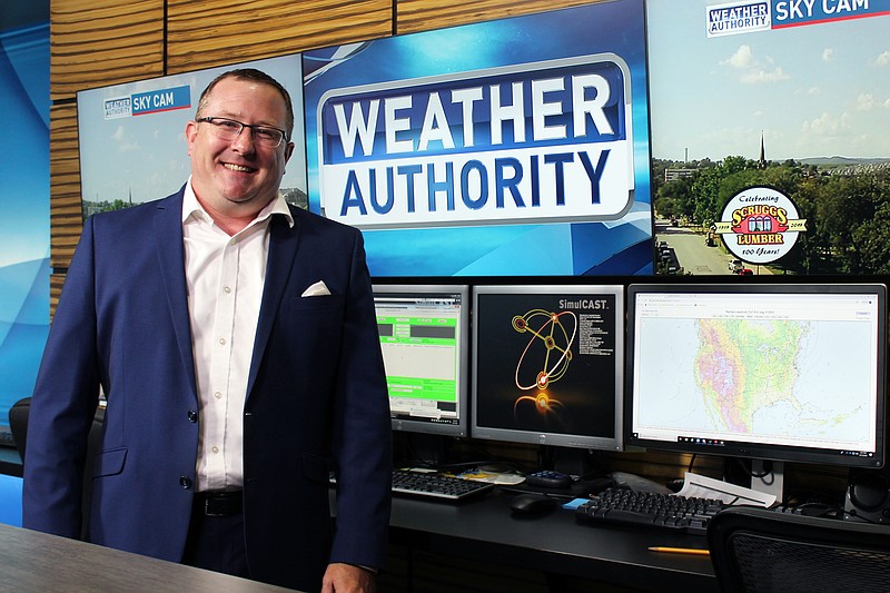
KRCG 13 Chief Meteorologist Zach Paul loves his job.
But the night of May 22, it was a stressful one.
"We cover 21 counties, and it seemed that the majority of them at one point or another had some sort of a severe weather alert," Paul remembers.
He started cutting into regular programming around 7:15 p.m., with severe weather reported around Boonville.
"The closer you get to 10:30, 11 o'clock, 11:30, the closer it was getting to the lake and Jefferson City," he said. "Personally, a lot of that night is a blur. I can tell you when we started; I can tell you when we stopped. In between, there was so much. This was the busiest day that I've covered."
A storm spotted near the Lake of the Ozarks area around 10:30 p.m. continued gathering strength. As it approached Eldon, its velocity - the strength of the winds inside a potential tornado - was tracking as high as Paul had ever seen.
"The disadvantage that we have in Mid-Missouri is the fact that radars that cover our area are in Kansas City, they're in St. Louis, they're in Springfield. And they hit Mid-Missouri at about 8,000-10,000 feet, about a mile and a half to 2 miles, depending on where you're located," he explained. "So there's a lot of space between where you're seeing the clouds spin and the ground itself. And so a lot of times, we'll see these strong couplets or these strong readings inside the radar, but that doesn't always translate to what's making it to the ground."
In this case, he had even less information about what was happening on the ground than he might otherwise, as a chat room with the National Weather Service, frequently used by meteorologists and media for ground-truth reports, had gone silent.
"We weren't getting any reports," he said. "Sometimes, that's good news either because the folks are in their basements, they're in their safe place, or for the fact that there is nothing happening."
Now, he's glad people took the warnings seriously.
"I didn't know that this was as severe or as real of a threat until the reports came in that Eldon was without power," he said. " I've covered hundreds of tornadoes and broken into numerous hours of programming over my career, and most of the time, it ends up in a rural area where it may damage trees, it may damage an outbuilding or garage or shed, some crops maybe. But, I've never really experienced it in my career where it's actually gone into a major metropolitan area.
"And Eldon, of course, was the first one that got the brunt of that. And then it stayed on the ground."
In the 30 miles between Eldon and Jefferson City, the radar showed the storm gaining strength and weakening sporadically.
"That's common in these situations. But for it to be on the ground for 30-some-odd miles, that's uncommon," Paul said. "The closer it kept getting to Jefferson City, the more and more that I could feel it in my throat that this was actually heading for a metropolitan area, that people were really in the way of this path."
Paul got his first look at the damage in Jefferson City as photos and videos aired on KRCG's live broadcast.
He was on the air until about 6 a.m. the next day - about 11 hours straight.
"I was told my tone was completely different this time - unbeknownst to me. I didn't know that. But I knew it was serious," he said.
He rested, briefly, then spent much of the day after the tornado talking with residents along heavily damaged Capitol Avenue.
"They wanted to tell me their stories," he said, remembering what his mentor, Bryan Busby of KMBC Kansas City, had told him about the way viewers often connected with meteorologists as they report live on weather events. "That could be their therapy, just telling you what they were experiencing, what they were going through, because that was sort of helping them get through it. So I listened to countless stories for the next several days. And it's therapeutic for me, too.
"Some of them are strangers, and they just wanted to tell me their story. For me, I want to know. I'm in a completely different seat and situation, but together we're a part of the same story."
Other "Heroes of the Storm"
There were nearly 20 individuals and organizations who received plaques Saturday, Aug. 27, 2019, at a ceremony recognizing them as "Heroes of the Storm" for their actions during the May 22 tornado. Read their stories:
Laurel Dunwoody, with Love2Nourish,
Steve Barnes, Alan Braun, Gary Braun and Justin Braun, with the Cole County Fire Protection District,
Kevin Riley and family, with Riley Auto Group,
Lorenzo Davis Jr., with Building Community Bridges,
Thorpe Gordon Elementary School teachers,
California Women's Business Council,
Doug Schrimpf, with Doug Schrimpf Construction,
Thomas Jefferson Middle School and Larry Linthacum, with Jefferson City Public Schools, and