
Photo Gallery
Conway ArtsFest

Conway celebrated arts at various shops, galleries and outside venues. Friday night's cold weather moved the jam session inside but didn't dampen the spirit of the musical crowd. Some people brought their own instruments, others jumped in for impromptu music making with Marco Granados and Un Mundo.
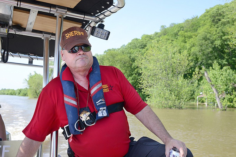
The flooding on the Osage River may not yet be at historic levels, but the water level was still high enough Wednesday to prevent the Osage County sheriff from immediately getting to where he wanted to go.
Osage County Sheriff Michael Bonham and Deputy Jesse Henson viewed the flooding on the Osage firsthand Wednesday afternoon as they took the sheriff's office's 24-foot boat out on the water - as far as they could before the high water level prevented them from going any further downstream from Osage City.
"In '93, they tell me it was up over this," Bonham said of the railroad bridge that crosses the Osage River at Osage City.
The water level at the bridge Wednesday was not as high as that - still a few feet below the underside of the bridge - but high enough that it prevented Bonham and Henson from taking the boat under the crossing to get to Bonnots Mill and the Missouri River.
Upstream, Bonham and Henson estimated the last lock and dam before the Missouri was 10-12 feet underwater.
"We're going to make sure there's nobody stranded that couldn't get ahold of law enforcement or any first responders. We're just checking flood levels for the most part - see what kind of damage is going on; what our recovery is going to be after this," Bonham said of the purpose for being out on the water.
Bonham said there had not been any water rescues with the current flooding, but he could see Wednesday that several homes had been inundated, and there was damage to some docks.
Bonham said pictures he took of the damage are sent to the county's emergency manager, who then keeps track of it.
He also said he's been checking on Osage City for the Cole County Sheriff's Department.
The sheriff's office has had the boat since November, Bonham said. The 24-foot, tunnel-hulled boat is a former U.S. Coast Guard craft, he said - acquired through the federal government's 1033 program that transfers excess Department of Defense equipment to federal and state law enforcement agencies.
The life jackets aboard were also 1033 acquisitions - from the Navy and Air Force, as well as a bulletproof life jacket from the Army that Henson was wearing.
Bonham said that ballistic life jacket only "cost us shipping," versus the $955 it originally cost the federal government.
He said it's planned the boat will be out again on the Memorial Day, Fourth of July and Labor Day weekends.
"It could be very dangerous," he said of what the Osage River conditions could be for Memorial Day weekend. As eager as boaters may be to get on the water, the flooding could create strong currents and a lot of floating debris.
Ameren Communications reported to the News Tribune on Wednesday that Bagnell Dam's flood gates further upstream on the Osage had been open Tuesday, but were closed Wednesday morning.
Ameren said the Lake of the Ozarks was at its "guide curve" level of 659.2 feet - 8/10 of a foot below "full pool" stage.
Ameren added Truman Lake also closed its flood gates.
Bagnell Dam would release only as much water as the lake receives at the upper end - at least until the Missouri River starts falling.
Bagnell was running water through the turbines and generating some electricity, "at normal levels," according to Ameren.
On the Missouri River, the U.S. Army Corps of Engineers announced Wednesday in a news release that "releases from Gavins Point Dam are forecast to increase to 60,000 cfs beginning Thursday, May 23."
"The decision comes after precipitation totaling between 2 to 5 inches fell over central Nebraska and much of South Dakota over the last 2 to 5 days. Because of the rain, inflows into Oahe, Big Bend, Fort Randall and Gavins Point Dams have been increasing and causing pool levels to rise," according to the Corps.
"The forecast rise at Oahe Dam and Fort Randall Dam includes storing runoff in their exclusive flood control pools. Releases from Gavins Point Dam will allow more water to pass through the system and slow the rise in the pool levels at these projects," the Corps' news release added.
A post on the Southern Boone County Fire Protection District's Facebook page Wednesday reported Hartsburg was not organizing a sandbag effort at that time.
"Members from the Southern Boone County Fire Protection District, Boone County Office of Emergency Management and the Village of Hartsburg Board of Trustees continue to work together and monitor river levels. If river levels dictate a need for sandbagging, we will reach out via a press release and through local social media groups," according to the post.
The Missouri River towns of Marion and Sandy Hook have started to feel the effects of the river flooding farms and potentially homes.
Missouri 179 that heads north and southbound on the outskirts of Sandy Hook was closed by the Missouri Department of Transportation due to water easing up over the roadway.
The Missouri River at Jefferson City was forecast by the National Weather Service on Wednesday to crest Friday at 32.4 feet; and crest near Chamois at 29 feet Friday.
The Osage River at Mari-Osa Campground was forecast to remain above its major flood level of 25 feet through most of Friday; the level was 25.5 feet Wednesday.
News Tribune reporter Bob Watson and California Democrat reporter Liz Morales contributed to this story.