
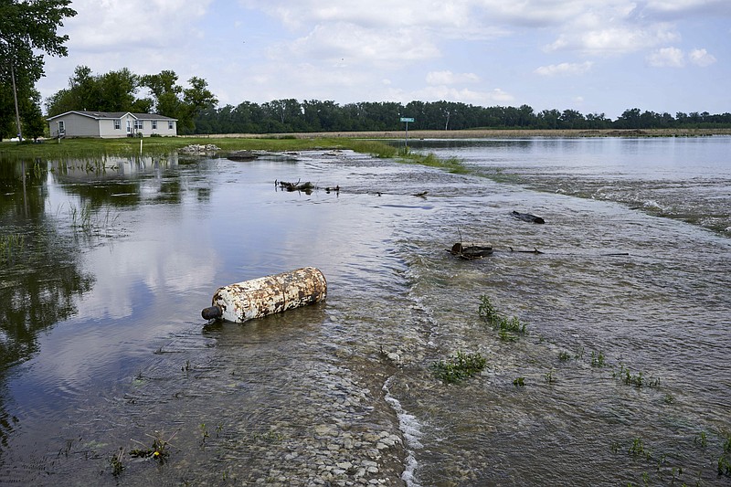
OMAHA, Neb. (AP) - The surging Missouri River is being filled with more than twice the normal amount of water from an upstream reservoir so more flooding is likely, and the heavy releases may continue for months.
The flooding could be particularly bad in communities that sit behind levees that were damaged by massive flooding in March that primarily affected smaller communities and farms along the river in the four states downstream of the dams.
The U.S. Army Corps of Engineers says the amount of water being released from Gavins Point Dam on the Nebraska-South Dakota border will remain at 75,000 cubic feet per second for at least a month because of all the recent rain. That's about 85 percent of the amount of water in an Olympic size swimming pool.
"The 75,000 (cubic feet) level is going to be having water above the banks at a number of places for a very long time," said John Remus, who oversees water management for the reservoirs along the river. "Those areas that have been flooded will continue to be flooded to some degree."
The Corps will reassess the amount of water being released into the river, and if there hasn't been significantly more rain than expected the amount could be reduced this summer. However, it is still likely to remain above average into the fall.
Some answers to common questions about the ongoing flooding:
WHY ARE THE RELEASES HAPPENING?
During the March flooding that caused at least $3 billion in damage in Nebraska, Iowa, Missouri and Kansas, the Corps held back some water in the upstream dams after heavy rains and snow melt in Plains states caused the flooding.
However, holding back that water essentially filled up two of the reservoirs - Fort Randall in South Dakota and Oahe, which also is in South Dakota but stretches into North Dakota. Combined with spring rains and melting snow, that forced higher releases from the dams.
Much of the flooding this spring was caused by heavy rains that fell downstream of the dams, but plenty of water has been flowing into the river upstream.
The Corps predicts 50 million acre-feet of water will flow through the reservoirs along the Missouri River this year. That would be the second-highest total ever behind only the 61 million acre-feet seen during the massive flooding in 2011.
WILL FLOODING CONTINUE?
More flooding is likely in places protected by levees that were damaged in March because few have been repaired.
Levee repairs have been hindered by the extent of the damage and lingering floodwaters. Keeping the river level high will continue to make it difficult to reach some levees, and more damage may be caused.
"You're going to see continuing problems and recurring problems," Remus said.
Because of the additional flooding that is likely, Remus said the repair schedule for those levees will be affected.
"Levees are saturated and the prolonged water against them is dangerous," said Tom Waters, chairman of the Missouri Levee and Drainage District Association. "The system is overwhelmed with little hope in site. Even after the crest passes the water is remaining high. The prolonged high water will also delay repairs to breached levees. The result will likely be more flooding in many areas again next spring."
WHAT DO COMMUNITIES THINK?
Communities sitting behind busted levees and battling the latest deluge are alarmed.
In northwest Missouri, Holt County emergency management director Tom Bullock said every levee in the county, except one, has multiple breaches. When the worst flooding happened in March, about 95,000 acres were underwater. However, with so many levees busted, water can flow in through the breaches any time water levels rise. Currently, about 80,000 acres are flooded, preventing farmers from planting a 2019 crop.
"They don't leave any room in the pool up there to hold anything so it looks like 2011 all over again," Bullock said. "The water isn't going down enough for us to get any levee repairs done. We will be flooded all summer."
In Jefferson City, Missouri, floodwater had filled the basement of the Turkey Creek Golf Center with about 4 feet of water. Turkey Creek owner Danny Baumgartner told the Jefferson City News-Tribune that he's had about a dozen people at times helping to sandbag. He said water coming down the Missouri River from the dam releases "just threw a lot of water on us" but added "you just battle through it."
WHAT HAPPENED IN 2011?
Upstream runoff this year is second only to 2011, when the corps released massive amounts of water from reservoirs that had filled to overflowing.
The resulting torrent easily overmatched earthen levees along the river in Iowa and Missouri, tearing football field-sized holes in berms protecting thousands of acres of prime farmland and forcing the closure of heavily-traveled bridges and roads.
Government officials in downriver states accused the agency of caring more about protecting river navigation and recreation at the northern reservoirs than controlling flooding further south.
Many people who live along the river generally contend that the water levels in the upstream reservoirs should be kept low so they can handle large influxes of runoff. Upstream, boating and fishing enthusiasts want higher levels in the reservoir to support recreation. Likewise, barge owners want to make sure the water level is high enough that water can be released through the summer and fall to keep their vessels afloat.