
Spotty showers across Mid-Missouri over the past week helped alleviate drought conditions in some places, but drought conditions still worsened as a whole.
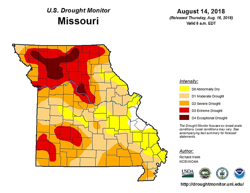
A weekly drought update from the U.S. Department of Agriculture shows parts of of northern Moniteau, Cole and western Callaway counties now are experiencing extreme drought conditions.
"When you look at the state of Missouri, and Central Missouri in particular, it's really a mixed bag," said Mark Fuchs, a hydrologist with the National Weather Service in St. Louis.
Severe drought conditions now cover almost all of Cole County. About the same portion of Callaway County sits in severe drought conditions as last week. The NWS still lists parts of southern Osage County as abnormally dry, the lowest level on its drought monitor.
Over the past 90 days, parts of the Jefferson City area have received between 1-8 inches less rain than normal, according to NWS data.
Parts of northwestern and southwestern Missouri appear to have been hit the worst by the drought, with several counties in northwestern Missouri now in the USDA's exceptional drought category, its fourth and worst drought category.
In parts of northwestern Missouri, some areas have received less than 10 percent of normal rainfall totals over the past 30 days, Fuchs said.
Areas around Jefferson City may see rain Thursday night, Fuchs said. A rain chance Sunday night into Monday morning may drop about a quarter-inch of rain near California and the Lake of the Ozarks area.
Fuchs cautioned, though, that sometimes during droughts forecasting models overestimate the amount of rain that may fall.
"I have pretty high confidence the rain we'll get next week will be as much as the weather predictions are predicting," Fuchs said. "I'd be surprised if we got more than we've been indicating."
Recent cool temperatures and high humidity also have helped farmers because less water evaporates from row crops like corn and soybeans when it feels cool and humid.
"Anytime in the summer where temperatures are not in the 90s and 100s and you have dry conditions, that cuts down on evapo-transpiration," Fuchs said.
Gov. Mike Parson directed the Missouri Department of Natural Resources in July to activate a drought assessment committee to help coordinate resources to address the impacts of this summer's drought. Already the state has taken steps to help farmers.
The DNR's Soil and Water Districts Commission granted a statewide variance that allows grazing on land that normally cannot have livestock on it. Missouri has $2 million free to help farmers plant cover crops, to address inadequate feed and forage and to address other natural resource concerns relating to the drought.
Farmers in counties affected by the drought can apply for assistance at local USDA Natural Resource Conservation Service centers until Aug. 31. Applications in counties with severe drought conditions will be given priority.
The USDA forecast corn production of 14.6 billion bushels, up 356 million bushels from the agency's July prediction. The agency also predicted average corn yields of a record 178.4 bushels per acre.
In its August World Supply and Demand Report, the USDA noted Illinois, Indiana, Nebraska, Ohio, North Dakota and South Dakota are expected to have higher-than-normal yields. Missouri, Minnesota and Kansas are expected to have below-average corn yields, according to the report.
Despite the drought in lower Midwestern states, average prices for corn are forecast at $3.10-$4.10 per bushel, down 20 cents from the agency's July prediction.
Soybean production is forecast at 4.59 billion bushels, up 276 million bushels from July's forecast because of higher than expected yields. The USDA forecast season-average soybean prices of $8.90 per bushel, down 35 cents from its July prediction.