
The city's Planning and Zoning Commission unanimously approved the Historic Southside/Old Munichburg District and Neighborhood Plan during Thursday's meeting, sending it to the Jefferson City Council for approval.
The plan, which will be a component of the city's Comprehensive Plan, will be used to revitalize the historic southside neighborhood over the next 20 years. The city plans to rezone several areas in the neighborhood, encourage more commercial and residential developments, improve roads and interchanges, and create new parks.
The plan was introduced by Capital Region Medical Center more than a year ago. CRMC President Gaspare Calvaruso said the hospital started looking at ways to improve the surrounding neighborhoods after it invested $37 million in a 2014 expansion project.
"We want to make sure the area we work in is thriving and vibrant and safe," he said.
While the neighborhood houses several features like The LINC wellness center and views of the Capitol, about 14 percent of the homes in the area are unoccupied, and 20 percent of the buildings are in poor condition, according to the plan.
CRMC sought out H3 Studio, a St. Louis firm, to create the revitalization plan two years ago. During the past year, the city has held several workshops and meetings to hear comments from local residents, stakeholders and businesses.
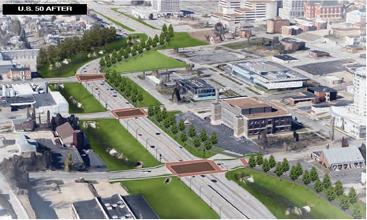
The plan contains 10 goals, which are spread out in four phases. Some of the changes involve revitalizing the area around Dunklin Street, expanding the park and greenway system, improving U.S. 50 by making it more pedestrian-friendly and providing more housing options near Lincoln University.
One project involves developing a park along Wears Creek, which would be an extension of Washington Park. Senior Planner Eric Barron said the plan calls for flood-prone areas to be converted to park land.
The biggest, and possibly final, goal is to redesign the Stadium Boulevard and U.S. 54 intersection by utilizing at least three roundabouts. This would not occur for about 20 years.
According to the plan, the 54 interchange "does not function well in its current form," and by improving this section, it could improve traffic flow and lead to future redevelopment along Jefferson Street and Christy Drive.
The plan also calls for the creation of a Community Development Corporation, which is an organization that would help guide the revitalization of the area.
Barron said while the plan does call for rezoning and redevelopment, the city plans to preserve the history as it revitalizes the area.
"Jefferson City has a lot of history, and the Old Munichburg area is a key part of Jefferson City's history, perhaps second to the downtown area - so it's an important area," he said. "I think residents, the city all know that it's a historic area, and I think in general there's a desire to protect that history and expand on that. But at the same time, there are areas that could benefit from redevelopment. Often when redevelopment occurs, it strengthens the core parts of the
neighborhood."