
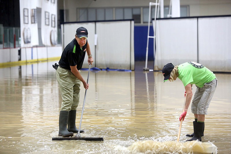
For the second time in about six weeks, flash flooding along Wear's Creek forced Jefferson City's Ice Arena to close.
The flooding came as the Jefferson City area received more than 3.5 inches of rain from midnight Friday through 7 a.m. Saturday, as measured by the National Weather Service at the Jefferson City Memorial Airport.

The torrential downpours that began late Friday night prompted the Weather Service to issue various flash flood advisories that expired in the early morning hours Saturday for much of Mid-Missouri.
The ice arena had just re-opened last week after being cleaned-up, repaired and building a new ice base following a similar flash flood in early August.
But this time, Parks, Recreation and Forestry department division director Phil Stiles told the News Tribune Saturday morning, the flooding was about two feet lower than 5 weeks ago.
"A lot of the electrical features, I don't think, were under water this time," he explained. "The good thing about this flood is we had not replaced any of the flooring so it is all concrete floor around the dasherboard area.
"We are hoping the clean-up process will go a lot quicker and a lot smoother this go-around."
Still, after the clean-up and repairs, the ice arena has to have ice, and it was destroyed by the muddy flood waters.
"Depending on how many man-hours we have, and who is working, it could be a week to a week-and-a-half process," Stiles said.
He's not sure why flash flooding now is a problem.
"We have never had flash flooding that reaches into the ice arena before this year," Stiles said. "We don't know the cause is."
Saturday's flash flooding forced the cancellation of this weekend's "Ice Theatre," which had been scheduled for 1 and 4 p.m. shows both Saturday and Sunday.
And in his weekly column last week, Stiles had promoted the ice arena as offering "a variety of public skating sessions throughout the week."
He said Saturday morning: "That's all we ask, again, is patience from all the users. We feel your pain.
"We'll get the ice arena up and running as quickly as possible, and if we do need any help, we'll certainly get that word out."
The city already filed a claim with its insurance carrier, he said, and started its clean-up efforts Saturday.
Jefferson City's fire department was in the area, flushing away the mud left on the streets by the high waters that also covered the Lions and Eagles ball fields nearby.
Mud was left on the parking lot and streets next to Lions Field.
And leaves and some debris were caught in the fence between the field and the creek.
The flooding also left mud on the Washington Park skateboard area, tennis courts and horseshoe pits.
Chris Wilson, the Jefferson City Convention and Visitors Bureau's sports and film sales manager, surveyed the damage around the ice arena, then told the News Tribune: "It's disheartening because there were things scheduled for this weekend, and people were excited about having the ice time and skating season and the hockey season and the different shows."
Still, he said, "We'll rally together as a community and get it cleaned up, get the ice back down and get the support that Parks and Recreation and the support groups need.
"We'll get back up on our feet and move as a community - that's what we do."
Wilson didn't see the two flash floods as having a major impact on tourism - unless the trend continues. Only then will flooding along the creek become "part of the conversation" with convention or event planners.
Motorists stranded
Although several instances were reported where emergency personnel in the Jefferson City area were called to flooded areas for motorists needing assistance, only one of those was included in a formal report.
The Missouri State Highway Patrol reported two Jefferson City residents - Albert J. Krachenfels, 27, and Abigail R. Toebben, 22 - received minor injuries when their westbound 2008 Chevrolet Silverado, driven by Joseph G. Krachenfels, 60, "travelled into a large hole in the roadway that was created from previous floodwaters."
The accident happened at 2:50 a.m. Saturday, on Elston Road, a mile east of Route T.
Rapidly rising water also caused a water rescue in the area of Missouri 179 and Route Z in Cole County, where 179 drops down a hill to cross a creek then crosses a lower-lying section of land. No other details were available about that rescue.
Low-lying city streets and area roads reported to have gone under water early Saturday included West Miller and Broadway streets just south of the U.S. 50/63 Expressway and West Stadium Boulevard in the area of the two roundabouts near Wears Creek, between Missouri Boulevard and West Edgewood.
Some areas reported trees and power lines down.
The periods of heavy rain prompted the National Weather Service to issue flood advisories and warnings for several area streams.
Moreau River: The National Weather Service in St. Louis issued a flood warning for the Moreau River near Jefferson City until Monday afternoon.
Flood stage is 17 feet, and at 4 p.m. Saturday, the stage was 20.1 feet - almost 5 feet deeper than at 4 a.m. Saturday.
A crest of about 20.8 feet was predicted early this morning, with the river falling back below flood stage this afternoon.
Maries River: A flood warning was issued for the Maries River near Westphalia until this afternoon.
Flood stage at Westphalia is 10.0 feet, and at 4 a.m. Saturday, the stage was 12.76 feet.
But by 4 p.m. Saturday, the river had fallen to 5.6 feet.
Although other area rivers were filled with more water than usual, there were no Weather Service flooding predictions Saturday along the Missouri, Osage or Gasconade rivers.
The closest to a possible flood condition was at Chamois, where the Missouri River flood stage is 17 feet, and the river was expected to crest early this morning at 16.3 feet.
Earlier coverage:
Flash flooding in Mid-Missouri covers roadways, prompts rescues
Additional resources:
Weather watches, warnings, advisories