
ST. LOUIS (AP) - Rain-swollen rivers were either cresting or starting to fall across much of Missouri on Monday, but a National Weather Service flood expert warned that more rain is on the way over the next several days and the water could rise again.
The Cuivre River was falling in northeast Missouri, the Meramec near St. Louis was at crest, and the Mississippi River south of St. Louis was expected to reach its high point on Tuesday.
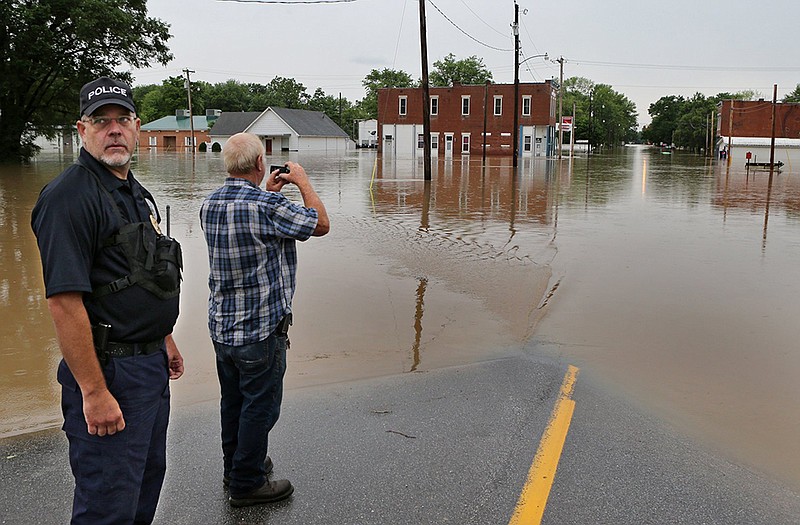
The sudden flooding started in mid-June thanks to torrential rains that worsened with the arrival of Tropical Depression Bill. Parts of Missouri got 5-7 inches of rain in a 24-hour period late last week.
Hydrologist Mark Fuchs of the weather service office near St. Louis said heavy rain is in the forecast for this week along the Iowa-Illinois border, and by the end of the month along the Missouri River basin from Nebraska through Mid-Missouri.
All of that water would eventually make its way into the Mississippi River at the confluence with the Missouri near St. Louis, and to points south.
"That's something we're going to have to watch closely," Fuchs said.
"The worst may or may not be over."
More heavy rain also forced the Missouri Department of Transportation to close U.S. 61 at Troy, about 50 miles north of St. Louis, where it passes over the swollen Cuivre River. The bridge closed Friday but reopened briefly before closing again Sunday. The Cuivre level was dropping quickly and the bridges were expected to reopen by Monday evening.
All told, roads were closed in 62 locations across Missouri.
The Mississippi River was at "major" flood stage from near Ste. Genevieve south through the Missouri Bootheel. Buyouts since the 1993 flood have removed most homes from harm's way, and few homes were endangered.
The Mississippi was expected to crest at 40 feet Tuesday near Ste. Genevieve - 13 feet above flood stage. Storm sewers backed up into some basements in Ste. Genevieve, and flooded the lower level of the county health department building, said Felix Meyer, emergency management coordinator for Ste. Genevieve County.
The Mississippi also was expected to crest Tuesday at Cape Girardeau, reaching 111/2 feet above flood stage. A flood wall protects Cape Girardeau but officials were monitoring nearby Allenville and Dutchtown, each with about 100 residents.
The Meramec River was several feet above flood stage at Arnold, Valley Park and other towns near St. Louis. Several parks and ballfields were flooded, along with several roads. The Meramec was expected to drop below flood stage by Wednesday.
In northwest Missouri, 4 inches of rain early Sunday caused flooding in Excelsior Springs, Mosby and Richmond.
The Clay County Sheriff's Department said four adults and two children were rescued Sunday night after becoming trapped in high water.