
The following roads in Cole County are still closed due to flood waters:
ENGINEERS RD
MEADOWS FORD ROAD
MURPHYS FORD ROAD
NORTH BRANCH ROAD
PAYNE ROAD
RAILROAD STREET IN OSAGE CITY
WATER STREET IN OSAGE CITY
WATERFORD ROAD
The following roads are now open after being closed due to flooding in Cole County:
OAKLAND ROAD
PAYNE ROAD
LOESCH ROAD
BAINER ROAD
VAUGHN FORD ROAD
ROCKHOUSE SPUR
EAST LOHMAN ROAD
CAMPBELL ROAD
ZION ROAD
BUFFALO ROAD
WALNUT ACRES ROAD
EARLIER COVERAGE
Gov. Jay Nixon on Thursday declared a state of emergency as heavy rain continues to cause flash flooding and flooding across the state.
Many parts of Missouri have seen several inches of rain over the past week, and remnants of tropical depression Bill are bringing even more through Friday night.
Nixon has activated the Missouri State Emergency Operations Plan, which helps state agencies coordinate more directly with local jurisdictions on emergency services.
"With more heavy rain in the forecast, we will continue to remain in direct contact with law enforcement and local officials as we work to protect lives and property," Nixon said in a statement.
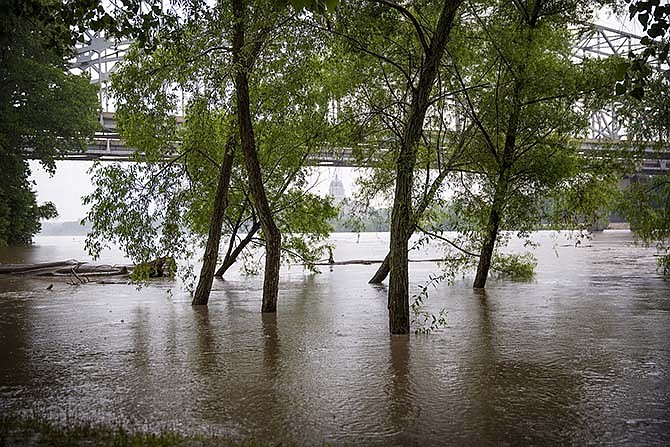
The Missouri River crested at several spots on Thursday, including Hermann in eastern Missouri. The river was 8 feet above flood stage in the historic German community, swamping ag land and low-lying fields in and near town.
Forecasts from the National Weather Service in St. Louis, however, show Mid-Missouri river levels should drop drastically in the next few days.
After small drops during the day Thursday, the Missouri River in Jefferson City was predicted to fall from 27 feet to around flood stage of 23 feet Saturday afternoon.
The Moreau River in Jefferson City stood at nearly 26 feet Thursday, but by this afternoon, it is predicted to drop down to flood stage of 17 feet and continue to fall throughout the weekend.
The Osage River near St. Thomas reached 18 feet Thursday and was predicted to go up another foot by this afternoon before slowly falling and reaching the flood stage of 16 feet Monday morning.
Cole County Public Works officials said Thursday afternoon that some roads had re-opened after being closed due to flooding earlier. Those roads are: Payne Road, Vaughn Ford Road, Campbell Road and Walnut Acres Road.
Roads still closed due to flooding include: Bainer Road, Buffalo Road, East Lohman Road, Engineers Road, Loesch Road, Meadows Ford Road, Murphy Ford Road, North Branch Road, Oakland Road, Railroad Street in Osage City, Rockhouse Spur, Water Street in Osage City, Waterford Road, Zion Road.
To find out more about road conditions around Central Missouri, visit modot.org/central.
The Mississippi River was still on the rise, and expected to reach major flood stage from Ste. Genevieve south through Cape Girardeau.
The National Weather Service said the river was projected to reach 41.9 feet on Monday near Ste. Genevieve, nearly 15 feet above flood stage. That would be the fifth-worst flood ever, flooding railroad tracks and shutting down several roadways.
Smaller rivers are also expected to reach major flood stage, including the Meramec, Bourbeuse and Cuivre rivers.
The Missouri Department of Transportation lists 24 locations across the state where roads are closed due to flooding. Nixon and Missouri Highway Patrol officials urge motorists to avoid driving through water on roadways. A man died this week near Sullivan after his vehicle was pushed off the road by moving water and overturned.
Updates:
Mid-Missouri radar and forecast
MoDOT traveler information map
Flood statements by National Weather Service, St. Louis
Hydrological map by National Weather Service, St. Louis