
After more than a year of work, Jefferson City is ready to start moving forward on new signage throughout the area.
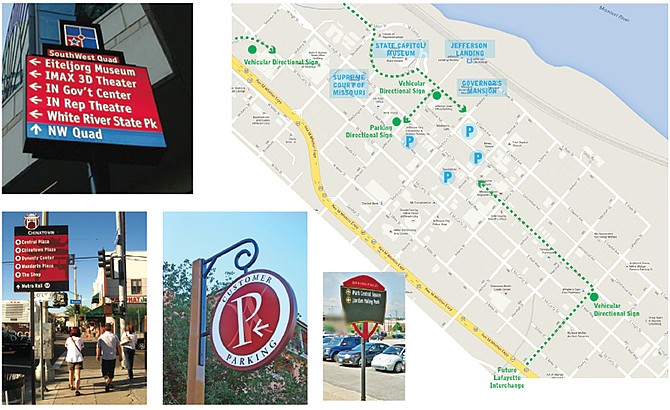
Earlier this week, the Capital Area Metropolitan Planning Organization (CAMPO) board of directors approved the final draft of the regional wayfinding plan, which seeks to help visitors and residents locate districts, landmarks and other venues in town through signs and informational kiosks.
In January, the city was awarded $214,000 in grant funds from the Transportation Alternatives Program to implement a wayfinding plan, "including fabrication and installation of wayfinding signage for downtown Jefferson City and from the Katy Trail leading into Jefferson City."
Alex Rotenberry, transportation planner, said the CAMPO board's approval is the green light for the Public Works Department to get started on the finer details of each sign before beginning to place them. Rotenberry said the first phase of the project will focus on placing signs in the downtown core and connecting to the Katy Trail, as that was the section specified in the grant application. He said that phase will need to be finished by spring 2016, per the grant's guidelines.
"Now, it's the exciting reality of some of the signs actually coming to fruition," Rotenberry said.
Rotenberry said public works staff now will look at content for signs, placement and the intended audience (cars, pedestrians or cyclists) before beginning to place the final signs.
"We have an idea of the logo and color schemes," Rotenberry said, noting examples in the plan may not represent the exact color scheme for downtown signs. "They're pretty good-looking signs."
The total cost of the project is $267,500, and the grant funds cover 80 percent of that. The majority of the 20 percent local match has been provided by several groups, including Capital Region Medical Center, the Jefferson City Convention and Visitors Bureau, the Discover Jefferson City Foundation, Downtown Jefferson City, the East Side Business Association, the Historic City of Jefferson and the parking division of the city.
The final wayfinding plan and other design documents can be found at jeffcitymo.org/pps/campo/Wayfinding.html.