
UPDATE: At 4:30 a.m. Thursday, Ameren Missouri reported it had increased the output of its floodgates at Bagnell Dam into the Osage River from 72,000 cubic feet per second to 78,000.
That follows earlier increases in the rate of release, rising from 61,000 cfs on Wednesday afternoon to 70,000 on Wednesday night, with 11 of 12 floodgates discharging water.
Additional increases may be necessary, as the Lake of the Ozarks basin received around 1.7 inches of rain between 9 p.m. and midnight Wednesday as thunderstorms moved through central Missouri, and there's more rain in Thursday's forecast.
The lake level was reported at 661.7 feet above sea level at midnight, and in spite of increased discharge through the dam, it rose to 662.2 at 4:30 a.m. Full pool is measured at 660 feet.
Hourly discharge rates are available online at apps.ameren.com/HydroElectric/Reports/Osage. Recorded updates from Ameren are also available by calling 573-365-9205.
The heavy rainfall Wednesday night closed a number of area roads due to flash flooding, as well as downing power lines and trees in some locations. Some of the roads reopened a short time later as water receded.
The additional rainfall will result in a number of river level forecasts being revised. See the "update" links at the bottom of this article for real time information about river levels and flood advisories.
Posted Wednesday evening, July 1:
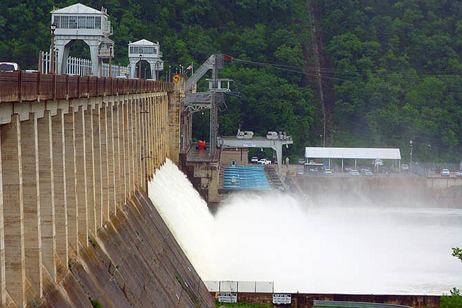
Heavy rains prompted Ameren Missouri on Wednesday to open 11 of the 12 floodgates at Bagnell Dam by 20 percent. The release is expected to swell the Osage River across Mid-Missouri.
Alan Sullivan of Ameren Missouri said 3 inches of rain fell across the Lake of the Ozarks basin Tuesday night with some areas receiving 5 inches or more. Additional rainfall was forecast for Wednesday night.

The Lake of the Ozarks was at 659.19 feet above sea level at midnight Tuesday, and had risen to about 661.2 feet by 3 p.m. Wednesday. Full pool is measured at 660 feet.
Bagnell staff asked the Truman Dam to shut down its releases while the Bagnell Dam increased its gate operation from 40,000 cubic feet per second discharging Wednesday morning to 50,000, and then increased again Wednesday afternoon to 61,000. Hourly discharge rates are available online at apps.ameren.com/HydroElectric/Reports/Osage.
Sullivan predicted the Osage River was expected to rise about four feet total.
In St. Thomas, the National Weather Service forecast was for the Osage to rise from almost 16 feet Wednesday evening to 23 feet by Thursday night. The river is expected to fall to 18 feet on Saturday evening and close to flood stage of 16 feet by Monday morning.
"The river was already out of its banks, so this won't help," said Cole County Emergency Management Director Bill Farr. "We put the word out for those who live along the Osage through emergency messages so they're kept informed."
The heavy rain and thunderstorms were causing the closure of several Cole County roads, including: Meadows Ford Road; Murphys Ford Road; Vaughn Ford Road; Campbell Road; Payne Road; and North Branch Road.
Many of these roads are along the Moreau River near Jefferson City.
The forecasts show the Moreau River started a dramatic rise Wednesday morning, going from around 4 feet up to 10 feet by 5 p.m. The river is expected to crest at 27 feet Thursday night and then do a steep drop and fall below flood stage of 17 feet early Friday morning.
On the Maries River at Westphalia where flood stage is 10 feet, the river is forecast to crest near 14.2 feet Thursday afternoon and fall below flood stage Thursday night.
The Missouri River in Jefferson City had dropped to 20 feet by 5 p.m. Wednesday, but the forecast called for the river to have a small rise, reaching 22 feet by Friday night, a foot below the flood stage of 23 feet. It should stay around that level before going down again Saturday evening.
The forecasts assume no additional rainfall and thus, may change. Check water.weather.gov/ahps2/index.php?wfo=LSX for updates.
In Camden County, the rainfall damaged several roads, including four that will be closed until next week, county officials said.
The four closed roads are Doherty Road in the Climax Springs and Edwards area, Flippin Road in Climax Springs, Westwood Road in Camdenton and Carroll Cave Road near Richland are closed and need repairs.
"These roads are closed due to undermining of material," said Lee Schuman, Camden County Road and Bridge Department administrator and county engineer. "They are unsafe for drivers to travel on."
Schuman said the four roads are in heavy watershed areas and crews must wait for the water to recede.
There were additional reports of damage among smaller roads, such as ones in the Camelot Estates subdivision north of Camdenton. Run-off from excessive rainfall caused flooding in Camdenton, Cole Camp, Ha Ha Tonka State Park, Lake of the Ozarks State Park, Lincoln, Lowry City, Macks Creek, Truman State Park and Warsaw.
The good news is that the long-range forecast over the Fourth of July weekend calls for mild temperatures for this time of the year, with highs expected to be in the low to middle 80s on the Fourth of July and only slight chances for rain each day. Increased chances for rain come next week.
Updates:
Mid-Missouri radar and forecast
MoDOT traveler information map (state road closings)
National Weather Service, St. Louis