
Here's the evening weather advisory for Mid-Missouri from the National Weather Service:
...WINTER STORM WARNING REMAINS IN EFFECT FROM 6 PM THIS EVENING TO 6 AM CST MONDAY...
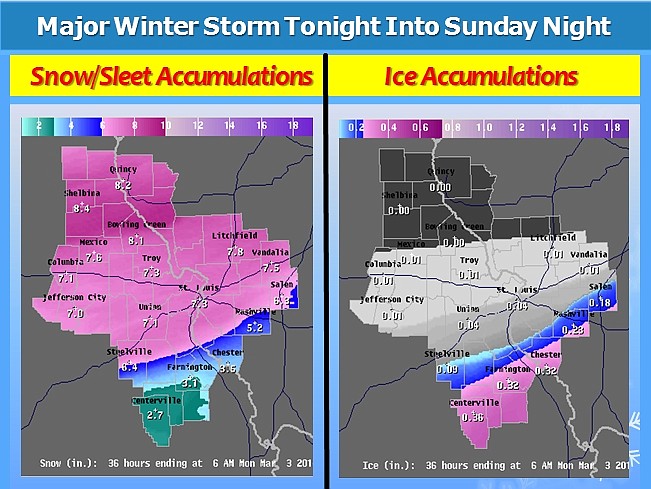
- TIMING... SOME LIGHT FREEZING DRIZZLE WILL DEVELOP THIS EVENING... WITH THE PRECIPITATION INCREASING IN INTENSITY AND BECOMING A MIX OF SNOW AND SLEET LATE THIS EVENING. THIS MIX WILL THEN CHANGE OVER TO ALL SNOW EARLY SUNDAY... WITH SNOW THEN CONTINUING THROUGHOUT THE DAY AND INTO THE EVENING.
- ACCUMULATIONS... SNOW ACCUMULATION OF 7 TO 10 INCHES... ALONG WITH A LIGHT GLAZING OF ICE.
- WINDS... NORTH 10 TO 15 MPH WITH GUSTS UP TO 25 MPH.
- IMPACTS... SNOW... SLEET AND ICE ACCUMULATION WILL CREATE HAZARDOUS TRAVEL CONDITIONS TONIGHT THROUGH SUNDAY NIGHT ACROSS CENTRAL AND EAST CENTRAL MISSOURI AS WELL AS SOUTHWESTERN ILLINOIS.
PRECAUTIONARY/PREPAREDNESS ACTIONS...
A WINTER STORM WARNING MEANS THAT A SIGNIFICANT AMOUNT OF SNOW... SLEET AND/OR ICE IS EXPECTED OR OCCURRING. STRONG WINDS ARE ALSO POSSIBLE.
Related:
Local forecast, radar, advisories (Mobile devices here)
MoDOT Traveler Information Map
Jefferson City street conditions
Earlier report:
With weather forecasts predicting March will enter like a lion, Mid-Missourians may be hoping the month will go out as a lamb with mild, pleasant temperatures.
From tonight through Monday morning, forecasters say Central Missouri will get a variety of wintry precipitation.
"Saturday night after midnight is when the real meat of the storm will hit. But in the evening hours, we'll probably see a mixed bag with freezing rain and sleet, and then snow, which will go through the day Sunday and into Sunday night," said meteorologist Tom Spriggs with the National Weather Service in St. Louis. "There could be some minor ice accumulations Saturday night since temperatures will be cold, in the mid-20s in the evening, so it won't take much to get things slick."
Spriggs said the grand total for this storm could be 6-7 inches of snow.
"There's still room for the forecast to change, but it looks like Sunday night or early Monday morning when it will end," he said. "As the snow moves out, very cold temperatures will come in, the kind you don't see this time of year. We'll get down to 0 degrees or a few degrees below that with wind chills around -15."
Local road crews are hoping this is the last storm they'll have to deal with this winter.
"We've had 12 storms so far this winter, and that's the all-time record since I've been counting them for us," said Britt Smith, Jefferson City operations division director. "This includes smaller storms, and looking back there were only two storms that I would call relatively large, one that dumped 5 inches and another that dropped 6-7 inches."
"We've had a big enough break to get our trucks and other equipment checked out so they are in good shape," said Cole County Public Works Director Larry Benz. "Supply wise, we're still in good shape. We've got 1,000 tons of salt on hand."
"We've got 1,500 tons of salt now, and it takes about 400 tons for a typical storm," Smith said. "When you think about it, with 250 miles of road, it takes a lot of salt whether it's a big or small storm."
Benz and Smith said if we do get a lot of ice, that could really hurt supplies.
"Ice burns through a lot of salt because you have to go out multiple times, and that takes away a lot of your resources," Smith said.
"By the end of this coming week, our temperatures are looking to be well above freezing during the day, and the long-range forecast we have shows that trend continuing," Benz said. "I just know I'm ready for spring."