
DAVENPORT, Iowa (AP) - Flooding concerns eased in much of eastern Iowa on Friday as the Mississippi River hit its expected peak in Davenport, though officials are still keeping a wary eye on flooding in Iowa City.
Officials are now turning their attention to points south along the river in Missouri and Illinois.
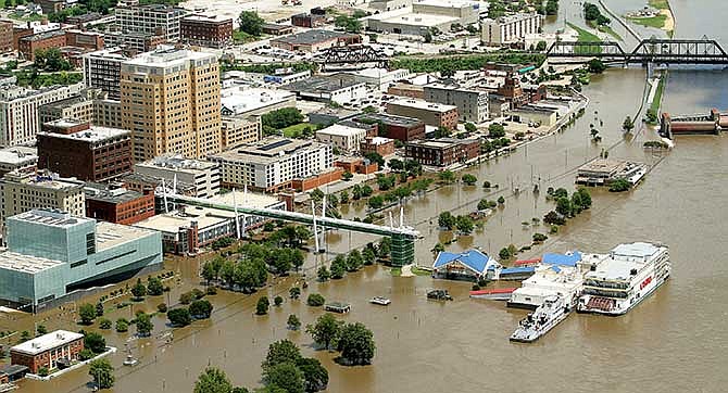
The National Weather Service reported that the Mississippi River crested in Davenport at 20.89 feet - well above flood stage of 15 feet but nearly two feet below the record set in 1993. The high waters caused flooding of low-lying areas along the river, such as River Drive in Davenport.
The level is expected to drop starting Saturday and settle below 18 feet by Thursday.
In Iowa City, the swollen Iowa River led the University of Iowa and the city to erect flood barriers last week.
While the flooding has hit some homes and businesses, it has not reached levels seen during the devastating floods of 2008 and 1993.
The U.S. Army Corps or Engineers predicted that Coralville Lake, a reservoir built to control flooding on the Iowa River, will crest Thursday just two feet below its emergency spillway. But emergency managers cautioned that any heavy rainfall in coming weeks could send the lake's waters over the spillway.
The National Weather Service forecast for the Iowa City area includes a 40 percent chance of thunderstorms Saturday night and a 50 percent chance on Sunday night.
"We have been sending our folks out to monitor the levees and communities that are being impacted," Sarah Jones, an emergency management specialist with the Corps in Rock Island, Illinois, said Friday. "There's been some evacuations of low-level areas right along the river."
In northern Missouri along the Mississippi River, the corps is preparing for flooding next week.
"We're at flood stage right now," said Davor Karic, a civil engineer with the Corps in St. Louis. "Most of the areas of concern are north of St. Louis. Once we get to where the Mississippi meets the Missouri River, it's not as much of a concern, because the channel is bigger, and we're not seeing flooding problems on the Missouri."
Corps officials had expected a Mississippi River lock and dam north of St. Louis to close to navigation Friday amid fears of worsening flooding. But by late Friday morning, the Corps had adjusted its expectation to close Lock and Dam 24 in Clarksville, Missouri, sometime Sunday.
Karic said lock and dam closes when the river's water level at Clarksville reaches 32.5 feet. It's expected to reach 33.5 feet on Sunday and crest at 35.4 feet - more than 10 feet above flood stage - on Thursday.
Further south at Lock and Dam 25 at Winfield, Missouri, the river was at 30.5 feet Friday, nearly five feet above the flood stage. It's expected to crest at 35.4 feet Thursday. Corps officials will close it to navigation when it reaches 33.5 feet.