
By JIM SALTER
Associated Press
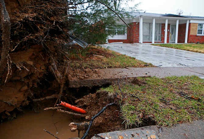
UNIVERSITY CITY, Mo. (AP) -- A tornado touched down in suburban St. Louis early on Thursday as a strong storm system rumbled across Missouri, but no one was injured from the twister.
National Weather Service meteorologist Jayson Gosselin said the tornado hit at 5:23 a.m., damaging at least 20 homes and downing power lines and several trees in University City in St. Louis County.
The storm was also apparently to blame for a natural gas leak in University City that forced the evacuation of some residents. Several roads were also blocked by storm debris. The city opened a shelter at Heman Park for evacuees.
Gosselin said it was fortunate that the damage in University City wasn't worse, and that no one was hurt.
"There's a lot more to hit when a tornado is in an urban or suburban area, and a lot more people as well," he said.
Storms knocked out power in the University City area and near Richwoods in a rural area about 50 miles southwest of St. Louis. The utility Ameren Corp. reported about 6,000 Missouri outages as of midmorning Thursday.
Rainfall was heavy over much of the state, especially in western Missouri. The National Weather Service said portions of Johnson County had more than 5 inches of rain, causing flash flooding that forced evacuation of some homes in the Warrensburg area. Several homes were damaged.
The weather service said Highway T in Johnson County was closed after rushing water washed out three culverts. At least two motorists had to be rescued from flash flooding. There were no immediate reports of injuries.
Flash flood and thunderstorm warnings were common across most of the state.
Gosselin said the unsettled weather was expected to end by Friday. Temperatures will drop -- highs over the next five to seven days will be mainly in the 50s, but conditions will be dry, Gosselin said.
Related: