
More than a decade ago, a 142-acre boon of prime, downtown Jefferson City land became available in theory when the Department of Corrections received the go-ahead to move out of the Missouri State Penitentiary (MSP).
By 2004, the inmates were moved in to the new Jefferson City Correctional Center just east of the Algoa prison, and the MSP was vacated.
Thus began the community's dream of what could be done with the old state penitentiary.
Task forces, committees, commissions and public officials researched, surveyed and debated.
Priorities emerged.
A plan was set and the General Assembly formed the MSP Redevelopment Commission to oversee it.
The MSP Master Plan still is the go-to guide for possible development.
In May 2012, after Nathan Nickolaus, Jefferson City's administrator, was quoted in the News Tribune saying the Master Plan was "dead," the commission reaffirmed that its primary objective is to see the Master Plan completed.
Just a few months earlier, the Jefferson City Area Chamber of Commerce's Transformation action team found the plan still relevant and earmarked $17 million from its proposed, half-cent sales tax plan for MSP and conference center projects, including renovations and repairs of the prison's old housing units.
But the ballot issue, which had projected $41 million to be collected over 10 years, failed in February 2012.
The MSP-related surveys from Transformation matched those from the MSP Task Force more than a decade ago - preserving the historic essence of the site has been the community's top priority.
"The (Transformation) action team came to the same conclusions as the Master Plan," Sarah Alsager reported to the MSP Commission. "It concretely showed MSP is on the minds of everyone in our community."
Preservation

The top historic preservation priorities have remained with:
Housing Unit 4, also known as A Hall, where an eventual museum is planned.
Housing Unit 1, also used at one time as the Administration Building, which followed the Master Plan as today's entrance to the site.
Housing Units 3A and B.
The Upper Yard Wall and Towers.
The gas chamber, which some have said should be relocated within the complex, while others argue it should remain at its current site.
Once responsibility for managing the site shifted in 2005 from the Department of Corrections to the Office of Administration, caretaking and maintenance funding has been scarce.
Several grants and one-time allocations have cleared unimportant buildings, repaired major issues, improved the exterior along Lafayette Street, and other minor concerns. Inmate work crews and community volunteers have come in through the years to help with cleanup and minor maintenance.
"We have worked in sync with (city and chamber officials) on some of the necessary cleanup of that site," Gov. Jay Nixon told reporters Friday.
But critics say that, without electric power, environmental climate regulating and regular care, the choice buildings to be preserved actually are in decay and may not be viable if left as is.
The Missouri Preservation Alliance designated the MSP on its list of endangered buildings in 2010.
The MSP Master Plan identifies the upper yard and the accompanying structures as the "historic and community campus."
It occupies the western half of the grounds within the walls, roughly from Lafayette Street east to Cherry.
Although the gas chamber is some distance from the rest of the historic campus - it's next to the east wall, along Chestnut Street - the MSP Master Plan suggested it stay in place, "to convey the separation and isolation inmates must have felt."
The Transformation task force and the Jefferson City Convention and Visitors Bureau, which hosts frequent tours through the site, have suggested the gas chamber be moved to the upper yard/historic campus area.
Likewise, the original Master Plan shows the "natural resources campus" as a 50-acre green space far east of the walls - between the former Surplus Properties area and Ellis-Porter/Riverside Park - which should be left undisturbed. Yet, chamber officials and developers both have showed interest in the oak-hickory forest - with shaped ridge tops (formed by use as prison farmland years ago) and steep ravines - for residential development.
MSP Commissioner Gene Buschmann acknowledged the ease of developing on a new site, but defended the idea of keeping the land's natural state, saying, "Once the green space is gone, it is gone."
Following the plan
The city's greenway recently added an extension along that green space from Ellis-Porter/Riverside Park to the state Natural Resources department's Lewis and Clark Building. A more rugged hiking trail cuts through the green space to a Missouri River overlook.
That follows the Master Plan's intentions to create foot traffic and encourage interaction with the natural area.
The natural resources campus "must be buffered from development pressures and protected for the greater good of current and future generations," the Master Plan said.
The Lewis and Clark building and the state health lab also followed the Master Plan, creating the beginnings of the "office campus."
State government was afforded a total 750,000 square feet of office space, including the 120,000 square-foot DNR building and the 80,000 square-foot health lab. They hoped for an additional presence of private business offices in a designated 250,000 square feet.
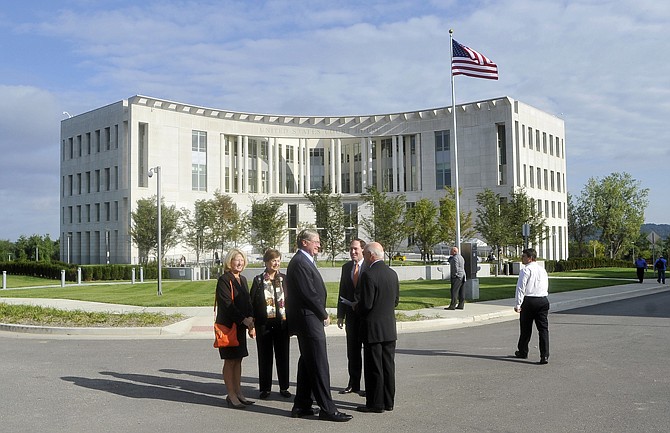
The federal courthouse fulfilled the "public service campus" part of the plan, too.
All three of these construction projects followed the Master Plan's design guidelines to blend with the long-standing buildings on site.
And the coming interchange at Lafayette Street and the U.S. 50/63 Expressway started as a wish on the Master Plan schematic.
But the Master Plan has been flexible, too.
The city grant for demolition targeted buildings along the path of the Master Plan's MSP Parkway, the eventual main artery through the site.
The Master Plan originally was designed with a new MSP Parkway to extend from East State Street at Marshall (at the west end of the prison grounds) through the site to East Capitol Avenue near Dawson Street (near the old International Shoe factory building).
Chestnut Street, which the city already has improved, also would link with the parkway.
That design was revised when the federal courthouse materialized.
Now, the parkway would begin at the end of Lafayette Street, which the city and county extended in support of the site's redevelopment.
The elaborate circulation plan included four-lane streets with tree-lined medians - but the 2012 Chamber Transformation plan targeted that idea as a place to scale back.
The Community Development Block Grant acquired by the city paid for the clearing of nearly a dozen buildings, including four factory buildings and the old diesel plant in the Chestnut Street-Capitol Avenue area, allowing for road creation and future access for new construction.
At the same time, the city also received a Brownfield grant, which helped with hazardous cleanup of a century of waste disposal on the prison site, and unknown remnants from the various factories.
One of the biggest changes from the original Master Plan is parking.
The 3,850-space, multi-level parking garages envisioned on the artist's rendition now are reflected in a few surface parking locations.
The Lewis and Clark Building deliberately chose to have little employee parking, to encourage public or alternate transportation.
The public service campus may have been designed with a new Cole County Jail and Justice Center in mind, but they were built near the Cole County Courthouse, instead.
And the MSP Redevelopment concept originally included private office and retail space, a museum, library and science center.
Additionally, a pedestrian plaza was planned at the intersection of East Capitol Avenue and Lafayette Street, above structure parking.
The federal General Services Administration did not include such parking with the federal courthouse.
The "public assembly campus" has received the least action so far.
Three hotels with 800 rooms were idealized in the Master Plan, along with exhibition and multi-purpose space, an auditorium, retail and restaurant space, a riverboat landing and access to Adrian's Island.
That campus also included the prison's Potato House converted to host a farmers market, interpretive center and a greenway trailhead.
Another pedestrian plaza was incorporated into the public assembly district, along with a boat landing.
The Missouri Naval Museum, a not-for-profit organized with the intent to establish a museum with retired U.S. Naval vessels on the Missouri River, hoped to partner with a future developer to bring their goal to reality.
None have gotten past the concept stage, so far.
Yet to come
The Master Plan names further sites, buildings and future uses.
Housing Unit 2 was targeted to become the Corrections department's offices.
Housing Unit 3 was suggested as the site for more than 15,000 square feet of state offices, as well as 60,000 square feet for record storage and a prison museum.
Housing Unit 4, the oldest building remaining intact, also was slated as an MSP museum.
The historic foundation of the former dining hall basement was the site targeted for 22,000 square feet of conference center space, plus another 11,000 square feet for dining rooms and a kitchen. That foundation was revealed during the Community Development Block Grant demolition of the prison's contemporary education building.
At some point, the historic area concept included the unearthing of the "Centennial Cells," beneath Housing Units 2 and 3, which would help interpret the many phases of prison history.
The former walls of a 19th-century housing unit were discovered in the 1980s, then recovered to be preserved for a later date.
The perimeter, limestone walls have also been a point of contention. The Master Plan incorporated "a majority of the existing stone wall with minor modifications." And several of the guard towers were proposed to be converted back to the original "castle" motif.
Economic development proponents often have cited removal of more of the wall as being important to progress.
Olivia Ingle of the News Tribune staff contributed information used in this story.
Related articles: