
Last updated at 9:29 p.m. Saturday
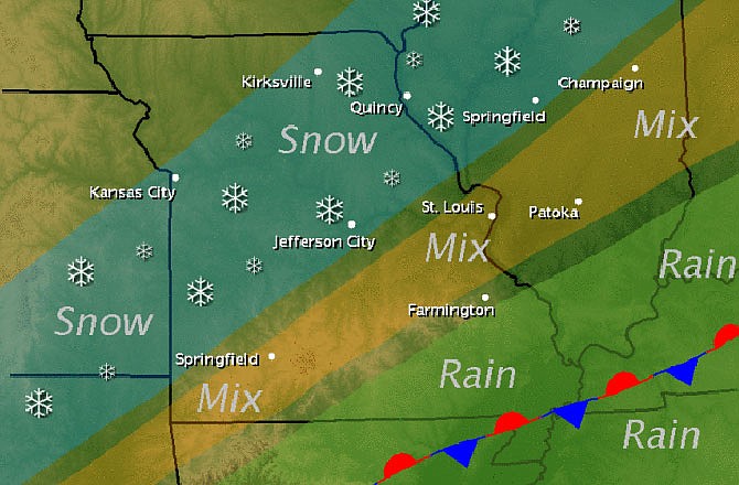
The National Weather Service reports winter weather is returning across Missouri with snow and sleet into Sunday morning. A Winter Weather Advisory is in effect until 6 a.m. Sunday.
Following an unseasonably warm Friday, a strong cold front moved southeast across the state Saturday, sending temperatures falling into the 30s.
Meanwhile, a weak area of low pressure developed along the front to the southwest and brought moisture back north up and over the cold dome of air.
Rain is expected to change to sleet and snow before ending, with minor sleet and snow accumulations possible along and north of I-44 in Missouri and I-70 in Illinois. This could cause hazardous driving conditions on untreated roads.
The NWS has issued the following statement for Mid-Missouri:
...WINTER WEATHER ADVISORY REMAINS IN EFFECT UNTIL 6 AM CST SUNDAY...
- TIMING...RAIN WILL CHANGE TO FREEZING RAIN FROM WEST TO EAST THIS EVENING. PARTS OF CENTRAL AND NORTHEAST MISSOURI WILL ALSO CHANGE OVER TO SLEET AND SNOW BEFORE MIDNIGHT. THE REMAINDER OF THE ADVISORY AREA WILL CHANGE OVER TO FREEZING RAIN DURING THE LATE EVENING AND CONTINUE INTO THE PREDAWN HOURS OF SUNDAY MORNING.
- ACCUMULATIONS...SNOW ACCUMULATION OF UP TO 1 INCH WILL BE POSSIBLE IN CENTRAL AND NORTHEAST MISSOURI...ALONG WITH A GLAZE OF ICE. ICE AMOUNTS WILL INCREASE TO AROUND ONE TENTH OF AN INCH IN EASTERN MISSOURI AND SOUTHWEST ILLINOIS.
- WINDS...NORTH 5 TO 15 MPH WITH GUSTS UP TO 30 MPH.
- IMPACTS...UNTREATED ROADS...PARKING LOTS...AND SIDEWALKS WILL BECOME VERY SLIPPERY.
PRECAUTIONARY/PREPAREDNESS ACTIONS...
A WINTER WEATHER ADVISORY IS ISSUED FOR A VARIETY OF WINTER WEATHER CONDITIONS...SUCH AS SNOW ...BLOWING SNOW ...SLEET ...OR FREEZING DRIZZLE AND RAIN. IT ONLY TAKES A SMALL AMOUNT OF WINTRY PRECIPITATION TO MAKE ROADS ...BRIDGES ...SIDEWALKS ...AND PARKING LOTS ICY AND DANGEROUS. IT IS OFTEN DIFFICULT TO TELL WHEN ICE BEGINS TO FORM ... SO DO NOT BE CAUGHT OFF GUARD.
Additional resources: