
Revised, updated article posted at 10:59 p.m. Sunday, June 19, 2011:
KANSAS CITY, Mo. (AP) - Several levees in northern Missouri were failing Sunday to hold back the surge of water being released from upstream dams, and locals braced themselves for more breaches as the Missouri River dipped but then rose again.
A hole in the side of a Holt County levee continued to grow, deluging the state park and recreational area in Big Lake, a community of less than 200 people located 78 miles north of Kansas City. The water - some from recent rain - started pouring over levees Saturday night and Sunday morning in Holt and Atchison counties, flooding farmland, numerous homes and cabins.
In Nebraska, a flooding alert was issued for a second nuclear power plant. But officials said it was the least serious emergency notification issued, and the public and workers are not threatened.
The Missouri River dipped by almost 1 foot after the Big Lake breach in Missouri, but water started to rise again by Sunday afternoon, said Jud Kneuvean, chief of emergency management for the U.S. Army Corps of Engineers' Kansas City District.
Kneuvean said he thought the flooding in the area wouldn't start for another day or two, but the water level surged by about 2 feet from Saturday morning to Sunday morning. The corps suspects that the culprit was an influx of rainwater that combined with a surge from a notch cut in the breached Hamburg, Iowa, levee to allow trapped water to flow back into the river.
"I looked at it mid-evening (Saturday) and told one of my co-workers, 'We are going to have levees start popping,'" Kneuvean said. "Within about an hour, we were getting the calls on them."
He said Big Lake is seeking permission to cut a relief hole in an already-damaged county levee to allow water trapped behind the levee to flow back into the river. The levee protects about 13,000 acres of farmland as well as the state park.
Presiding Holt County commissioner Mark Sitherwood said U.S. 159 was closed south of Big Lake because of water pouring over the road. Much of Big Lake's west side was underwater.
Most people left their homes well in advance of the flooding. Those who stayed were told Saturday night that water was flowing into the area.
Big Lake residents Juli and Steve Crenshaw, who stayed behind and used kayaks to get around, spent Saturday night scrambling to fix leaks in levees. After helping to shore up one levee, they headed to another one.
"But when we got there with sandbags, the levee was gone," said Juli Crenshaw, whose own basement was starting to take on water. "It was too late. So we left there and went to another levee and started working to save it."
The Big Lake area, where water has been high for the past couple weeks, has experienced major flooding in three of the last five years. Sitherwood said this year promises to be much worse following weeks of high flows and increasing releases from the main stem dams in Montana and the Dakotas.
In Atchison County, there was a nearly steady flow of water over a half-mile stretch of a levee near U.S. 136 and overtopping at various points to the north of that area, said Mark Manchester, deputy director of emergency management for the county. He said the river level in the county had reached 44.6 feet, the highest on record and about 4 to 5 inches higher than 1993 flooding levels.
The water was flooding several thousand acres of farmland, but so far no homes had been inundated since a breach this past Monday caused about a dozen homes to take on water, Manchester said.
Because of the high waters, U.S. 136 was closing near the Missouri-Nebraska border.
He said residents in the area had already evacuated their homes, and officials who operate the levee went up in a helicopter and saw several "pretty good size holes starting to form."
Kneuvean, the corps official in Kansas City, said that whenever a levee is being overtopped to the extent occurring in Atchison County, the best hope is that it stays intact for 12 hours. After that, "all bets are off," he said.
A complete breach of the levee could displace up to 200 more people.
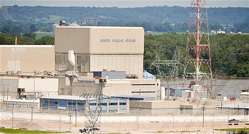
Meanwhile, in Nebraska, the flooding alert issued by the Nebraska Public Power District for the Cooper Nuclear Station near Brownville, Neb., didn't stop the plant from operating at full capacity Sunday. The Fort Calhoun Station, another nuclear plant along the Missouri River in eastern Nebraska, issued a similar alert June 6. That plant near Blair, Neb., has been shut down since April and will not be reactivated until the flooding subsides.
Jodi Fawl, spokeswoman for the Nebraska Emergency Management Agency, said water was flowing over a levee in the Brownville area and into farmland, but the levee was being built up to alleviate that.
(Associated Press writers Timberly Ross in Omaha, Neb., and Bill Draper in Kansas City, Mo., contributed to this report.)
Earlier coverage, posted at 4:47 p.m. Sunday, June 19, 2011:
KANSAS CITY, Mo. (AP) - Several levees in northern Missouri were failing Sunday to hold back the surge of water being released from upstream dams.
Authorities said water - some of it from recent rain - began pouring over levees Saturday night and Sunday morning in Holt and Atchison counties, flooding farmland and numerous homes and cabins.
A hole in the side of a Holt County levee continued to grow Sunday, deluging the state park and recreational area of Big Lake, 78 miles north of Kansas City.
U.S. Army Corps of Engineers spokesman Kevin Wingert said engineers would monitor the overtopping to try to determine how much of an effect it will have on water flows downstream. "It's too early to say what the full impact will be on it," he said.
Meanwhile, the Nebraska Public Power District issued a flooding alert Sunday for its Cooper nuclear power plant in southeast Nebraska as the Missouri River continues to rise.
The plant was operating Sunday at full capacity, and there was no threat to plant employees or to the public, Becker said. The plant is located south of Brownville, Neb., across the river from Atchison County, Mo.
Mark Becker, a spokesman for the Columbus, Neb.-based utility, said the "notification of unusual event" sent to the Nuclear Regulatory Commission was expected as the river swells above record levels. The declaration is the least serious of four emergency notifications established by the federal commission.
In Missouri, presiding Holt County commissioner Mark Sitherwood said U.S. 159 is closed south of Big Lake because water is pouring over the road, and most of the west side of the community is underwater.
"It's going through in one place that we know of and overtopped in numerous places and there is seepage everywhere," Sitherwood said.
He said most people evacuated well in advance of the flooding. Those who stayed were told Saturday night that water was flowing into the area. A few people live in cabins that have been built up and decided to stay, Sitherwood said.
"Everyone up here knows the routine," he said.
The Big Lake area, where water has been high for the past couple weeks, has experienced major flooding in three of the last five years. But Sitherwood said this year promises to be much worse following weeks of high flows and increasing releases from the main stem dams in Montana and the Dakotas.
"I know they wouldn't admit it, but this is a manmade event," said Sitherwood, echoing a sentiment common in the area that the Army Corps of Engineers is mismanaging the Missouri River. "Nobody is going to tell me it isn't. It is probably going to be historical."
The commissioner said his own home is at risk. "Thank you Corps of Engineers," he said.
The corps has said unusually heavy rains, not mismanagement, are to blame.
"What we are dealing with is a massive weather system that put a lot of precipitation in the system particularly in Montana and northern Wyoming in the month of May," Wingert said. "The end result is that water has to go somewhere."
In neighboring Atchison County, there was a nearly steady flow of water over a half-mile stretch of a levee near U.S. 136 and overtopping at various points to the north that area, said Mark Manchester, deputy director of emergency management for the county. He said the water was flooding several thousand acres of farmland, but so far no homes had been inundated since a breach this past Monday caused about a dozen of the homes to take on water.
Manchester said the river level has reached 44.6 feet, the highest on record and about 4 to 5 inches higher than 1993 flooding levels. He said minor flooding starts at 33 feet and major flooding at 43 feet.
He said residents in the area had already evacuated their homes, and officials who operate the levee went up in a helicopter and saw several "pretty good size holes starting to form."
The officials are predicating another breach, which could displace up to 200 more people.
"That would be worse case scenario," he said. "The information we are getting from the corps is that it's possible."
Associated Press writer Timberly Ross in Omaha, Neb., contributed to this report.