
OMAHA, Neb. (AP) - The scramble is nearly over to fill thousands of sandbags and construct last-minute levees to heights that haven't been needed in decades, but those preparations were only the first round of what's likely to be a summer-long battle against the bloated Missouri River.
Peak flows are expected to arrive early in the week in riverfront communities in Iowa, Kansas, Missouri and Nebraska as the U.S. Army Corps of Engineers completes a gradual increase of releases from dams upstream. The surge through the lower half of the river this week will expose any weaknesses in the flood protections.
"They're going to be as prepared as they can be," said John Benson, spokesman for Iowa's Department of Homeland Security and Emergency Management Division.
The Corps said this summer's Missouri River flooding could rival the record years of 1952 and 1993 in some places. Officials on Tuesday will increase releases from five of the river's dams to 150,000 cubic feet of water per second - more than twice the previous record releases.
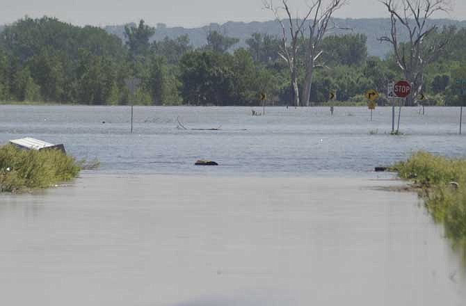
As a result, the river will rise 5 to 7 feet above flood stage in most of Nebraska and Iowa before continuing into Missouri, where it may rise 10 feet above flood stage in several places and flow over the top of at least 11 rural levees.
The record releases from the dams are expected to continue into August, so the river will remain high all summer, interfering with highway and rail traffic in the region. Parts of Interstate 29 have already been closed, and Union Pacific was re-routing some trains around Omaha.
Places in most danger of flooding include the small Iowa towns of Hamburg, Blencoe and Pacific Junction; the Nebraska communities of South Sioux City, Rulo and Plattsmouth; and St. Joseph in Missouri.
"I think there's a 50 percent chance it's going to be ugly. And there's a 50 percent chance we're going to squeak by," said James Gerweck, the emergency manager in southeast Nebraska's Richardson County.
About 60 miles north in Nebraska City, business has slowed at the Fingers, Faces and Feet salon because customers have cancelled appointments to help with sandbagging, owner Shelli Eyman said.
"The last thing they need to worry about right now is their nails and their hair," Eyman said.
Across the river, parts of Hamburg have been evacuated due to concern about a leaky levee and the possibility that the smaller Nishnabotna River that flows into the Missouri could back up and flood part of the town.
The Corps expects to complete a secondary levee by the time Missouri River flows reach their peak in case efforts to shore up the main barrier fail.
"It's all coming toward us," Fremont County Emergency Management Director Mike Crecelius said.
Crews from the Corps have been monitoring all the Missouri River levees closely, so any problems should be caught early, agency spokeswoman Monique Farmer said.
Members of the Winnebago Indian Tribe have been especially concerned about their casino about 20 miles south of Sioux City, Iowa, and only a half-mile from the river. The Tribal Council approved a spending freeze in case flooding closes the casino, which provides about 300 jobs and more than $5 million in annual revenue, treasurer Sarah Snake said.
More than 200 volunteers have built an 8-foot-high berm around the casino.
"Every day, we're checking and keeping a close eye on everything," Snake said. "It's frightening, really, to see what could happen."
Nearby in South Sioux City, Neb., water is expected to rise about 7 feet above the 30-foot flood stage. The Corps has built a 7,000-foot-long earthen levee, and a foam-and-concrete wall stands ready as a backup barrier.
Officials in the city of 13,400 haven't ordered any evacuations, but City Administrator Lance Hedquist said roughly 20 houses in the city's northwestern corner will be destroyed because they aren't protected by the new levee.
"We think we'll be ready," Hedquist said. "I feel very good about where we stand. The past few days have been stressful, but we had a plan."
Managers at A-1 Used Cars in South Sioux City have developed a contingency plan to move their fleet across the river, to higher ground in Iowa if the river rises even more than expected.
"We're just taking a waitand-see attitude," said manager Paul Johnson, who has lived in the area his entire life. "I think that everybody around here had a false sense of security with all the dams upstream on the Missouri River. We thought it was fool-proof."
The Corps has blamed the massive water releases through the 2,341-mile river on a combination of heavy spring rain in the Northern Plains and a huge Rocky Mountain snowpack.
The only time the river has been higher in Nebraska and Iowa during the past six decades was in 1952, when the river crested above 44 feet at Sioux City and above 40 feet at Omaha. This summer, the river is expected to reach as high as 37 feet at Sioux City and 36 feet at Omaha.
In Missouri, the 1993 flooding was generally worse than the 1952 flood. In 1993, the river crested at 48.9 feet near Kansas City and at 38.3 feet in Jefferson City. This summer, the corps predicts the river will reach as high as 39 feet in Kansas City and 35 feet at Jefferson City.
The Corps predicts the water will rise high enough to flow over the top of several levees in rural Holt County, Mo., flooding farmland. The Missouri River also is expected to flow over a Missouri levee on the opposite bank from Atchison, Kan., and to spill over levees on both sides of the Missouri-Kansas border as the river flows south from there.
Another likely flood spot, according to the corps, is the Kansas Department of Corrections Levee System near Leavenworth.
Even if levees hold initially, there are concerns about what will happen as the high flows continue for weeks or months.
"The longer the water sits on the levee slope, the more you begin to worry about seepage and slides and will the soil remain intact and cohesive?" said Jud Kneuvean, chief of emergency management for the corps' Kansas City district.
Online:
U.S. Army Corps of Engineers at www.nwk.usace.army.mil
National Weather Service river forecast at http://water.weather.gov/ahps/