
This winter, Mid-Missouri has been able to avoid the major storms that have been seen in other parts of the country. But, our luck has run out.
With snow continuing through this morning, forecasters with the National Weather Service predicted Mid-Missouri's total accumulation would range from 4-6 inches of the white stuff.
"We knew it would be a prolonged light snow before it really got going," said meteorologist Ben Miller said Monday. "This storm went according to plan. This was an all-snow event, no mixed precipitation, which is actually good. It's pretty unusual that we go down all the way to the Ozarks with all snow this time of the year. Usually the southern parts of the state get ice or sleet with a storm like this."
Miller said high pressure in the middle of the week, coupled with this fresh snow cover, will keep things cold. Single digit lows and wind chills around 10 below zero can be expected. He said it could be worse if the winds were stronger, but now they're forecast to be around 5-10 mph out of the northwest.
Miller also said by Friday and Saturday temperatures will climb into the 30's before falling again with another low pushing through on Sunday.
By Monday evening, many area school districts already had canceled Tuesday classes, including Jefferson City public schools, Blair Oaks, Eugene, Russellville, and Helias Catholic High School. See area closings for Tuesday.
Missouri State Government has implemented its Hazardous Travel Policy for state employees on Tuesday. See oa.mo.gov/hazweather_policy.php for details.
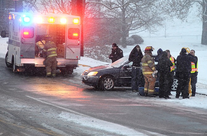
As expected with a storm like this, accidents were in abundance Monday afternoon keeping authorities and tow truck drivers busy. Most of the accidents were vehicles sliding off roadways and most didn't involve injuries.
"When we came in this morning, we knew we would be pushing snow, so we got ready," Jefferson City Parking and Street Director Britt Smith said Monday night. "We first started with a light coat of salt on our typical trouble spots, but by mid-afternooon the intensity picked up, so we went into full operation."
Smith said all 24 plow trucks ran Monday night until around 10 p.m. After that, an overnight crew of around six drivers kept going all over Jefferson City.
At 4 a.m. this morning, Smith said they were back to full operation.
"It takes us two to three hours to get all the streets cleared curb to curb, but that's after a snowstorm is done," he said
Smith said there have been no cutbacks for the snow removal service for the city.
"We're doing nothing different, it's exactly the same as what we always have done," he said. "We have 250 miles of road to cover and we get it as best as we can, but there will be times when a driver clears a street and before they get back to it, the snow intensity increases and the street is covered up again."
Cole County Public Works Director Larry Benz characterized this as a "standard snowstorm" on Monday night.
"The accidents started slowing down 6:15 p.m. as people finally made it home from work so that helped us," he said.
Benz said the main county crew was sent home around 9 p.m. They were brought back out around 4 a.m. this morning to get roads checked before rush hour.
"We had trucks ready and waiting Monday; it was just a matter of getting enough snow fall to do something," he said.
Like the city, Benz said there have been no cutbacks in snow removal for the county. He said road graders probably will be put back out this morning to go along with the 25-26 trucks they have working the roads.
The National Weather Service reports a Winter Weather Advisory for snow remains in effect until noon Tuesday. The advisory also states:
- TIMING...SNOW WILL CONTINUE THROUGH TUESDAY MORNING. THE SNOW WILL BE MODERATE AT TIMES CAUSING VISIBILITIES TO FALL TO 1/2 MILE. THE SNOWFALL INTENSITY SHOULD DIMINISH BY DAYBREAK TUESDAY.
- ACCUMULATIONS...TOTAL SNOW ACCUMULATION OF AROUND 4 TO 6 INCHES OF SNOW IS EXPECTED WITH LOCALLY HIGHER AMOUNTS POSSIBLE.
- IMPACTS...MOST ROADS ARE SNOW COVERED AND DRIVING IS HAZARDOUS.
PRECAUTIONARY/PREPAREDNESS ACTIONS...
ROADS MAY RAPIDLY BECOME SLIPPERY ONCE THE SNOW BEGINS...SO MOTORISTS SHOULD PLAN FOR A SLOWER THAN NORMAL TRIP. BE ESPECIALLY ALERT WHEN APPROACHING BRIDGES...OVERPASSES...AND CURVES.
Resources:
Missouri State Employee Hazardous Travel Policy
Local Forecast, Current Conditions
Area Radar, Severe Weather Statements